Groundwater depletion is the long-term, large-scale decline of water stored underground in aquifers, occurring when water is pumped out faster than natural recharge, mainly rainfall and snowmelt seeping back into the ground, can replace it. Unlike a surface reservoir, whose level anyone can see drop, groundwater depletion unfolds slowly and largely out of sight, which has allowed it to progress for decades in many parts of the world before becoming widely recognized as a serious resource problem.
How aquifers work and why depletion matters
An aquifer is a layer of permeable rock, sand, or gravel that holds and transmits groundwater, functioning something like an underground sponge that slowly fills from rainfall and snowmelt percolating down through the soil and slowly empties as water flows naturally toward springs, rivers, or wells. Many of the world’s largest aquifers took thousands of years to accumulate their current water stores, meaning that pumping them faster than they recharge draws down what is, on human timescales, close to a non-renewable resource, even though the water cycle will eventually refill them over a much longer geological timeframe. Groundwater depletion matters because aquifers supply a large share of drinking water and irrigation water worldwide, particularly in regions with limited or unreliable surface water, so a declining aquifer threatens both agricultural productivity and basic water security for the people who depend on it.
The scale of the problem
A 2024 study led by hydrologist Scott Jasechko and published in the journal Nature analyzed data from roughly 170,000 wells across nearly 1,700 aquifers in more than 40 countries, together accounting for about 75 percent of global groundwater withdrawals, making it one of the most comprehensive global assessments of aquifer trends attempted so far. Of the 542 aquifers with enough historical data to compare recent decades against the 1980s and 1990s, about a third showed more severe depletion in the twenty-first century than in those earlier decades, while roughly 20 percent actually showed slower declines than before, illustrating that groundwater depletion is accelerating in many places but not universally, and that local management and climate conditions can meaningfully change an aquifer’s trajectory.
What drives groundwater depletion
Irrigation for agriculture is by far the largest driver of groundwater depletion identified in large-scale studies, with cities and industrial users contributing a smaller but still meaningful share of total withdrawals. Declines are most pronounced in dry regions with extensive irrigated cropland, where farmers have limited alternative water sources and often rely on groundwater specifically because surface water is scarce or unreliable, a pattern documented across parts of the western United States, northern India, the Middle East, and northern China. Reduced rainfall recharging many of the same aquifers compounds the pumping pressure, since a drier climate both increases the agricultural demand for groundwater irrigation and reduces the natural recharge available to replace what is withdrawn, a double pressure that researchers increasingly link to broader climate change alongside purely local pumping decisions.
Land subsidence: a visible consequence
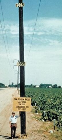
One of groundwater depletion’s most visible and often irreversible consequences is land subsidence, the gradual sinking of the ground surface that occurs when water is pumped out of compressible clay and silt layers within an aquifer system faster than it can be replaced, allowing those layers to compact permanently. California’s San Joaquin Valley became one of the best-documented examples of this process: research led by United States Geological Survey hydrologist Joseph Poland tracked a location southwest of Mendota where the land surface sank by close to nine meters between 1925 and 1977 as a result of sustained groundwater overdraft, a change famously illustrated by a roadside pole marked with the land surface’s approximate elevation in each of those years. Unlike the water itself, which can in principle be replenished given enough time, subsidence of this kind is generally considered permanent, since the compacted clay and silt layers largely lose their original capacity to hold water once compressed, which is one reason subsidence is treated as a particularly serious warning sign in groundwater management rather than simply a symptom that recharge can later reverse.
Responses and management
Researchers and water managers studying the Jasechko study’s findings and similar assessments generally point to stronger groundwater regulation, including pumping limits, metering, and permitting systems, as the most direct lever available to slow depletion, alongside measures such as managed aquifer recharge, which deliberately directs surface water into the ground during wet periods to rebuild storage for drier times. Shifting irrigation toward more water-efficient methods, such as drip irrigation, and in some cases shifting cropping patterns away from especially water-intensive crops in the driest regions, are also commonly recommended, though researchers quoted alongside the study cautioned that governments in much of the world still regulate groundwater far more loosely than they regulate surface water, leaving a persistent gap between the scale of the problem documented in the data and the strength of the policy response addressing it.
FAQs
Can a depleted aquifer be refilled? In principle yes, through natural recharge or deliberate managed recharge projects, but refilling can take decades to centuries for large aquifers, and if pumping-induced land subsidence has already compacted the aquifer’s clay and silt layers, some of its original water-storage capacity may be permanently lost regardless of how much water is later added back.
Is groundwater depletion mainly a problem in dry countries? It is most severe in dry regions with extensive irrigated agriculture, but it also occurs in wetter regions wherever pumping consistently outpaces local recharge, so climate alone does not determine risk; local water demand and management practices matter just as much as regional rainfall.
Key facts
- 2024 Nature study (Jasechko et al.): ~170,000 wells, ~1,700 aquifers, 40+ countries
- Irrigation is the largest driver of groundwater depletion globally
- San Joaquin Valley, California sank ~9 meters (1925-1977) from overdraft
- Land subsidence from aquifer compaction is generally permanent
Related concepts
Quick checkCan a depleted aquifer be refilled?Show answer
In principle yes, but it can take decades to centuries, and subsidence-related storage loss may be permanent.
Sources
- Jasechko et al.. Rapid groundwater decline and some cases of recovery in aquifers globally. Nature (accessed https://www.nature.com)
- USGS. Land Subsidence in the San Joaquin Valley. https://water.usgs.gov
Editorially reviewed by Specialty Digest Editorial TeamLast reviewed November 1, 2026Researched and drafted with AI assistanceReport an issue