Togo is a narrow, elongated country on the West African coast, stretching from the Gulf of Guinea northward between Ghana and Benin. Formerly a German and then French colonial territory, it is known today for its distinctive traditional architecture in the country’s north and for a long period of single-family political leadership since independence.
Where Is Togo Located?
Togo lies on the Gulf of Guinea in West Africa, a narrow strip of territory bordered by Ghana to the west, Benin to the east, and Burkina Faso to the north. Its short coastline, less than 60 kilometers long, contrasts with the country’s considerable north-south extent, which spans several distinct ecological zones. Lomé, on the coast, is the capital and largest city.
Geography
Togo’s terrain rises from a sandy, lagoon-dotted coastal plain in the south through forested plateaus in the center to savanna in the north. The Togo Mountains, an extension of the Atakora range that continues into neighboring Benin, cross the country diagonally and include Mount Agou, Togo’s highest point at 986 meters. The Mono River forms part of the eastern border with Benin, and a tropical climate with a pronounced dry season in the north gives way to higher, more consistent rainfall near the coast.
A Brief History of Togo
Colonial Partition
Germany established the colony of Togoland in 1884, developing infrastructure including one of colonial Africa’s first railway networks. After Germany’s defeat in World War I, the League of Nations divided Togoland between Britain and France as mandate territories. Following a 1956 plebiscite, British Togoland voted to join the Gold Coast, becoming part of independent Ghana in 1957, while French Togoland became the independent Republic of Togo in 1960.
Independence and Long-Term Leadership
Togo’s early postindependence politics were unstable, including Africa’s first successful military coup in 1963. Gnassingbé Eyadéma took power in a 1967 coup and ruled for thirty-eight years until his death in 2005, becoming one of Africa’s longest-serving heads of state. His son, Faure Gnassingbé, became president later that year following a disputed transition and has remained Togo’s dominant political figure since. A new constitutional framework adopted in recent years shifted Togo toward a parliamentary system, under which Faure Gnassingbé was appointed as the first President of the Council, a position that now holds executive authority, while the presidency of the republic has become largely ceremonial.
Government and Economy
Under Togo’s current parliamentary system, a bicameral Parliament, composed of the National Assembly and the Senate, elects both the President of the Republic and the President of the Council, with the latter exercising executive power. The ruling Union for the Republic party continues to dominate the country’s political landscape. According to the World Bank, Togo’s population reached approximately 8.6 million in 2025, and national poverty remains significantly higher in rural areas, at 58.2 percent, than in urban areas, at 26.2 percent. Togo’s Human Capital Index score of 0.43 indicates that a child born in Togo today would be only 43 percent as productive as an adult as they could be with full access to health care, nutrition, and education. The security situation in the northern Savanes region, where Togo has faced cross-border extremist threats linked to instability in the wider Sahel, has prompted a sustained state of emergency in parts of the north.
Culture and People
Togo is home to more than forty ethnic groups, the largest being the Ewe in the south and the Kabye in the north, alongside numerous smaller communities. French is the official language, while Ewe and Kabye serve as widely spoken national languages. Religious life blends Christianity, Islam, concentrated mainly in the north, and traditional African belief systems, including Vodun, which has deep historical roots along this stretch of the West African coast and is still widely practiced, particularly around Lomé.
What Is Togo Known For?
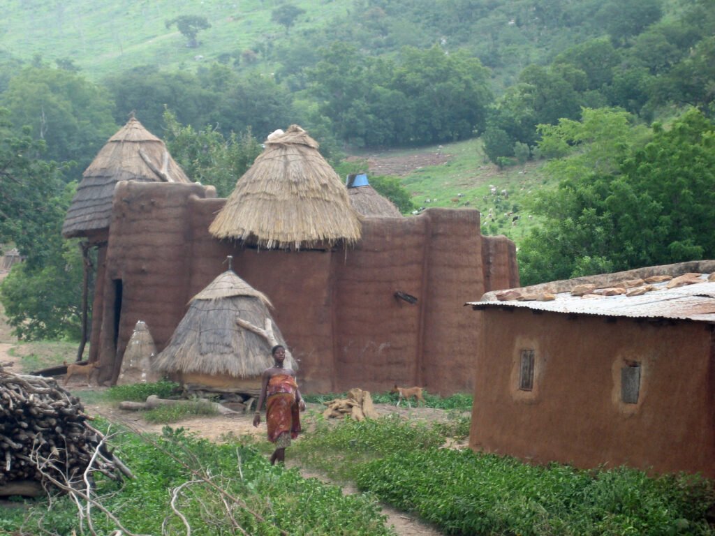
Togo’s most distinctive landmark is Koutammakou, the Land of the Batammariba, a UNESCO World Heritage cultural landscape in the country’s northeast. The region is known for its tata, fortress-like mud tower-houses with conical thatched roofs built by the Batammariba people, structures recognized by UNESCO as an exceptional example of architecture adapted to social and environmental needs and that continue to be built and lived in today. Togo is also known regionally for Lomé’s lively markets and for Africa’s long history of single-party and single-family political dominance under the Gnassingbé family.
Why Togo Matters
Togo’s colonial history, split between German, British, and French administration and later divided between two independent states, makes it a clear example of how arbitrary colonial-era borders reshaped West African political geography. Its Koutammakou cultural landscape preserves a living architectural tradition recognized as being of exceptional value, offering insight into how communities have adapted building practices to both social organization and the natural environment over centuries. Politically, Togo’s decades of continuous leadership by one family, and its recent constitutional shift to a parliamentary system, make it a closely watched case of long-term political continuity and constitutional change in West Africa.
Key Takeaways
- Togo is a narrow country on the Gulf of Guinea, bordered by Ghana, Benin, and Burkina Faso.
- French Togoland became independent Togo in 1960, while British Togoland joined Ghana after a 1957 plebiscite.
- Gnassingbé Eyadéma ruled from 1967 to 2005; his son Faure Gnassingbé has led the country since, now as President of the Council under a new parliamentary system.
- The population reached approximately 8.6 million in 2025, with poverty markedly higher in rural areas than urban ones.
- Koutammakou, the Land of the Batammariba, is a UNESCO World Heritage Site known for its traditional mud tower-houses.
- Ewe and Kabye are Togo’s two largest ethnic groups, alongside more than forty smaller communities.
Sources
- World Bank, “Togo Overview” (2026) [1]: worldbank.org/en/country/togo/overview
- World Bank Data360, Togo Economy Data [2]: data360.worldbank.org
- UNESCO World Heritage Centre, Koutammakou, the Land of the Batammariba [3]: whc.unesco.org
Key facts
- Population: approximately 8.6 million (2025)1
- French Togoland became independent Togo in 1960; British Togoland joined Ghana in 1957
- Gnassingbé Eyadéma ruled 1967-2005; son Faure Gnassingbé has led since, now as President of the Council1
- Rural poverty (58.2%) is far higher than urban poverty (26.2%)1
- Koutammakou is a UNESCO World Heritage cultural landscape known for its mud tower-houses3
Quick checkWhat is Koutammakou, Togo's UNESCO World Heritage Site, best known for?Show answer
Its traditional tata mud tower-houses built by the Batammariba people.
Sources
- World Bank. Togo Overview. 2026 (accessed Date accessed: 2026-10-04)
- World Bank Data360. Togo Economy Data. 2026 (accessed Date accessed: 2026-10-04)
- UNESCO World Heritage Centre. Koutammakou, the Land of the Batammariba. Undated (accessed Date accessed: 2026-10-04)
Editorially reviewed by Specialty Digest Editorial TeamLast reviewed October 4, 2026Researched and drafted with AI assistanceReport an issue