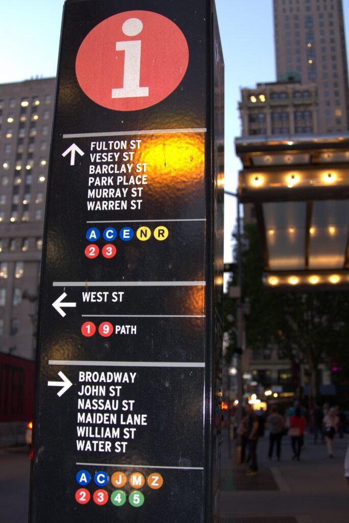
Wayfinding refers to how people orient themselves and find their way through physical space, as well as to the signs, maps, and other design elements created specifically to help them do so, a field that sits at the intersection of graphic design, architecture, and cognitive science.
Origins of the term
Urban planner Kevin Lynch introduced the term way-finding in his 1960 book The Image of the City, describing it as the consistent use and organization of definite sensory cues drawn from the surrounding environment to help a person navigate. Architect Romedi Passini broadened the concept considerably in his 1984 book Wayfinding in Architecture, extending it beyond mental orientation to cover signage, graphic communication, and audible or tactile cues, and Passini’s later collaboration with graphic designer Paul Arthur, Wayfinding: People, Signs and Architecture, published in 1992, became a standard reference for the field.
The wayfinding process
Designers typically break wayfinding down into four stages a person moves through: orientation, figuring out one’s current location and surroundings; route decision, choosing a path toward a destination; route monitoring, confirming that the chosen path remains correct while moving along it; and destination recognition, confirming on arrival that the intended destination has actually been reached.
Landmark signage systems
Designer Massimo Vignelli, working through the firm Unimark International alongside designer Bob Noorda, created the New York City Subway’s influential signage system beginning in the late 1960s, establishing a now-famous standardized, color-coded approach to transit wayfinding that influenced transit systems well beyond New York. Legible London, a system of more than fifteen hundred pedestrian signs introduced in the city, is often described as the largest urban wayfinding system in the world, and other major cities, including Dublin and Nashville, have since introduced their own comprehensive citywide systems.
Accessibility and standardization
Wayfinding design has increasingly been shaped by accessibility requirements, particularly following the 1990 Americans with Disabilities Act in the United States, with facilities such as the Canadian Museum for Human Rights adopting bilingual, tactile, and high-contrast signage alongside internationally recognized symbols. International standards, including ISO 7001 for public information symbols and ISO 28564-2 for location and direction signage, help keep wayfinding symbols consistent for travelers moving between different countries and transit systems.
Digital wayfinding
Digital tools have extended wayfinding well beyond physical signage, with indoor mapping applications, smartphone navigation, and interactive kiosks now guiding people through airports, hospitals, and shopping centers using the same underlying orientation, route-decision, and confirmation stages that physical signage has always addressed, adapted to a screen-based interface.
Wayfinding in healthcare settings
Hospitals present particularly demanding wayfinding challenges, since patients and visitors navigating large, complex buildings are often stressed, unfamiliar with the layout, and sometimes have limited mobility or vision, prompting many healthcare facilities to invest heavily in clear color-coding, consistent terminology, and strong visual landmarks to reduce confusion and anxiety during already difficult visits.
Wayfinding in transit and airports
Airports represent some of the most complex wayfinding environments designers address, requiring systems that guide travelers unfamiliar with a given terminal through security, customs, gates, and baggage claim, often across multiple languages and cultural contexts simultaneously, making consistent, universally recognizable symbols especially important in these settings.
Cognitive science and wayfinding
Wayfinding design draws directly on cognitive science research into how people build mental maps of unfamiliar spaces, including findings that people navigate more successfully when a space offers clear visual landmarks, logical sightlines, and a limited number of decision points, insights that inform how architects and planners lay out circulation routes even before any signage is added.
Branding and wayfinding
Wayfinding systems increasingly double as branding opportunities, with transit agencies, hospitals, and corporate campuses designing custom typefaces, color palettes, and iconography that simultaneously guide visitors and reinforce a consistent institutional identity, extending wayfinding’s practical function into the realm of graphic design and brand identity.
Evaluating wayfinding systems
Designers test wayfinding systems through methods including tracking how long people take to find a destination, observing where they hesitate or backtrack, and directly surveying users about confusing signage, feedback that helps refine a system after installation rather than treating the original design as final.
Multilingual wayfinding
Cities and institutions serving linguistically diverse populations increasingly design wayfinding systems with multiple languages or language-independent pictograms from the outset, recognizing that text-only signage can fail a significant share of the people actually trying to use it.
Wayfinding and sustainability
Effective wayfinding can also support environmental goals, since clear signage encouraging walking, cycling, or transit use over driving depends on travelers feeling confident they can navigate a route successfully, making thoughtful wayfinding design a quiet but meaningful contributor to broader sustainable transportation planning.
Wayfinding failures
Poorly designed wayfinding can measurably harm an institution, since confused visitors arriving late, missing appointments, or abandoning a visit entirely represent a real practical cost, which is why many large institutions now budget specifically for professional wayfinding consultants rather than treating signage as an afterthought added once construction is complete.
Everyday wayfinding cues
Even outside formal signage systems, people rely on informal wayfinding cues such as a building’s changing floor finishes, natural light from windows, or simply the sound and crowd flow near a busy entrance, reminding designers that the built environment itself always communicates orientation information whether or not a sign has been added to it.
FAQs
Who coined the term wayfinding? Urban planner Kevin Lynch introduced the term way-finding in his 1960 book The Image of the City, describing the use of environmental cues to help a person navigate.
What is the New York City Subway signage system known for? Designed beginning in the late 1960s by Massimo Vignelli and Bob Noorda through the firm Unimark International, it established an influential, standardized, color-coded approach to transit wayfinding that influenced systems well beyond New York.
Key facts
- Kevin Lynch coined 'way-finding' in his 1960 book The Image of the City
- The process breaks into orientation, route decision, route monitoring, and destination recognition
- Vignelli and Noorda designed the NYC Subway's influential signage system
- Accessibility standards like ISO 7001 keep wayfinding symbols consistent internationally
Related concepts
Quick checkWhat are the four stages of the wayfinding process?Show answer
Orientation, route decision, route monitoring, and destination recognition.
Sources
- Wikipedia, Wayfinding
- MoMA, NYC Subway Signage
Editorially reviewed by Specialty Digest Editorial TeamLast reviewed November 1, 2026Researched and drafted with AI assistanceReport an issue