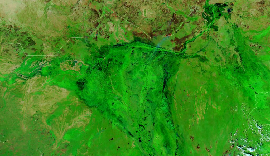
South Sudan is a landlocked country in northeastern Africa and, since 2011, the world’s newest internationally recognized sovereign state. It is defined above all by water: the White Nile runs through its center, feeding the Sudd, a vast seasonal wetland that is one of the largest in the world, and shaping a mostly Nilotic, agro-pastoral population still rebuilding after decades of civil war.
Where Is South Sudan Located?
South Sudan sits in northeastern Africa, bordered by Sudan to the north, Ethiopia to the east, Kenya and Uganda to the south and southeast, the Democratic Republic of the Congo to the southwest, and the Central African Republic to the west. The country formally separated from Sudan on July 9, 2011, and was admitted to the United Nations five days later, on July 14, 2011, making it, as of 2026, the most recently created country to have joined the UN. Its capital and largest city is Juba, on the banks of the White Nile.
Geography of South Sudan
The White Nile flows north through South Sudan from Uganda, and much of the country’s center is occupied by the Sudd, a seasonally flooded expanse of swamps, lagoons, and grassy floodplains. In 2006, the United Nations Environment Programme welcomed the designation of the Sudd as a Wetland of International Importance under the Ramsar Convention, describing a site exceeding 30,000 square kilometers that supports hundreds of thousands of migratory birds along with the Nuer, Dinka, and Shilluk communities whose lives follow its seasonal flooding. The Sudd now appears on South Sudan’s tentative list for UNESCO World Heritage status, alongside the Boma-Badingilo migratory landscape and the historic Deim Zubeir site.
Boma-Badingilo, in the country’s east, holds one of the largest overland mammal migrations left anywhere in the world. A study using GPS-collared animals recorded roughly 800,000 white-eared kob and 160,000 tiang moving between dry-season and wet-season ranges, with some kob traveling nearly 400 kilometers one way. Most of this migration route lies outside formally protected parkland, and the majority of the kob range, along with almost all of the tiang range, overlaps land leased to oil companies, setting conservation against the country’s main source of export revenue. South Sudan’s climate is tropical, with a dry season running roughly from November to March and a wet season for the rest of the year that floods the Sudd and the surrounding plains.
A Brief History of South Sudan
The territory that became South Sudan was administered as the southern provinces of Sudan under British and Egyptian colonial rule and then as part of independent Sudan after 1956. Governments in Khartoum, based in a mostly Arab and Muslim north, struggled to accommodate a south that was predominantly Nilotic, Christian, and traditional African in religion and culture, and the resulting tensions produced two long civil wars: the First Sudanese Civil War (1955 to 1972) and the Second Sudanese Civil War (1983 to 2005), among the deadliest conflicts of the late twentieth century. The 2005 Comprehensive Peace Agreement ended the second war and granted the south a six-year interim period with its own government, leading to a January 2011 referendum in which 98.83 percent of voters chose independence. South Sudan’s formal secession followed on July 9, 2011, and Salva Kiir Mayardit was sworn in as the new nation’s first president at an independence ceremony in Juba attended by then UN Secretary-General Ban Ki-moon.
Independence did not bring lasting peace. In December 2013, a political split between President Kiir and his former vice president, Riek Machar, escalated into a civil war fought substantially along Dinka and Nuer political lines. The conflict killed an estimated hundreds of thousands of people and displaced millions before a 2018 peace agreement brought Kiir and Machar into a unity government. A separate and still unresolved dispute concerns Abyei, an oil-producing border area claimed by both Sudan and South Sudan. The 2005 peace agreement designated Abyei as a demilitarized zone pending a final status agreement, but the UN Security Council has continued to report unauthorized armed forces in the area and stalled political talks between the two governments, and a UN peacekeeping force, UNISFA, still monitors the region. This remains a genuinely contested matter between Khartoum and Juba, and this article describes only what international monitors have documented rather than endorsing either side’s claim to the territory.
In September 2026, President Kiir dissolved the country’s transitional government, a step the Office of the President described as clearing the way for South Sudan’s first general elections, scheduled for December 22, 2026, more than fifteen years after independence.
Government and Economy
South Sudan has operated under the Transitional Constitution of the Republic of South Sudan, adopted in 2011 and since amended, which concentrates substantial authority in the presidency and establishes a bicameral National Legislature made up of a Legislative Assembly and a Council of States. Analysts of the transitional framework point to the absence of presidential term limits and to repeated use of executive decree as recurring features of governance during the post-independence period. The scheduled December 2026 elections are intended to replace this transitional arrangement with an elected government for the first time since independence.
The economy depends heavily on oil, which has historically supplied the large majority of government revenue and export earnings, and which must be shipped by pipeline through Sudan to reach export terminals, tying South Sudan’s finances closely to conditions in its northern neighbor. The World Bank reported that a major disruption to oil exports contributed to a sharp economic contraction, alongside hyperinflation and rising food insecurity, and has urged the government to diversify its revenue base and strengthen management of oil income. By 2025, the World Bank estimated that 87 percent of South Sudanese were living below the international poverty line of three dollars a day, with extreme poverty projected to rise further, and only about 5 percent of the population had access to electricity. By these measures, South Sudan is one of the poorest and most fragile economies in the world.
Culture and People
South Sudan is home to dozens of ethnic communities, the largest of which are the Dinka and the Nuer, both Nilotic peoples with long traditions of cattle-keeping and seasonal movement across the Nile basin’s floodplains. Other major groups include the Shilluk, Bari, and Azande, concentrated across the country’s ten historical states, which are in turn grouped into the three former regions of Greater Bahr el Ghazal, Greater Upper Nile, and Greater Equatoria. English is the official language of government and education, while Juba Arabic and dozens of indigenous languages are spoken across the country. The national flag, adopted at independence, uses red, white, black, green, and blue bands with a gold star, a design the government describes as representing the blood of those who died for freedom, peace, the people, the land, the waters of the Nile, and unity among the states.
Decades of conflict have driven one of Africa’s largest displacement crises. As of late 2026, more than 2.49 million South Sudanese were registered as refugees or asylum seekers in neighboring countries, with Uganda hosting the largest share, followed by Sudan, Ethiopia, and Kenya. This displacement has shaped South Sudanese communities both at home and across the region, and it remains one of the most consequential and best-documented facts about the country’s recent history.
What Is South Sudan Known For?
Globally, South Sudan is most often identified by three things: its status as the world’s newest country, the scale of the humanitarian crisis produced by its civil wars, and the Sudd, the vast Nile wetland that has shaped travel and settlement in the region since nineteenth-century explorers first struggled to push boats through its reed-choked channels. Conservationists increasingly point to a fourth: the Boma-Badingilo migration, a wildlife movement of a scale rarely matched outside East Africa’s most famous parks, though it remains far less visited and far less protected than the migrations of neighboring Kenya and Tanzania.
Why South Sudan Matters
South Sudan matters first as a test case in the difficulty of building a functioning state after war. Its 2011 independence, achieved through an internationally monitored referendum rather than through unilateral secession, was held up by the United Nations as a model of peaceful self-determination. The civil war that followed just over two years later, and the humanitarian crisis it produced, has made South Sudan a continuing focus of UN peacekeeping and regional diplomacy involving neighbors such as Ethiopia and Uganda. Its oil reserves also tie it closely to stability further north, since its only current export routes run through Sudan, meaning instability in either country quickly affects the other. For conservation science, South Sudan’s wetlands and migratory wildlife represent some of the least studied and most threatened natural systems on the continent. And for observers of political transition, its move toward long-delayed elections in December 2026 is being watched as a test of whether a country born from a referendum can complete the harder work of governing itself.
Key Takeaways
- South Sudan became independent from Sudan on July 9, 2011, after 98.83 percent of voters backed separation in a January 2011 referendum, and it joined the United Nations five days later.
- The Sudd, a Nile floodplain exceeding 30,000 square kilometers, is one of the world’s largest wetlands and a Ramsar-listed site now on South Sudan’s UNESCO World Heritage tentative list.
- The Boma-Badingilo landscape hosts roughly 800,000 migrating white-eared kob and 160,000 tiang, one of the largest overland mammal migrations on Earth.
- A civil war from 2013 to 2018, fought largely along Dinka and Nuer political lines, followed independence and displaced millions of people before a 2018 peace agreement.
- More than 2.49 million South Sudanese were living as refugees in neighboring countries as of late 2026, and the World Bank estimated extreme poverty at 87 percent in 2025.
- The economy depends heavily on oil exports shipped through Sudan, leaving South Sudan’s finances highly exposed to regional instability and global price swings.
- South Sudan’s first general elections since independence are scheduled for December 22, 2026, following the September 2026 dissolution of its transitional government.
Sources
- United Nations, South Sudan Member State Profile
- UN News, As South Sudan Celebrates Independence, UN Vows Support in Quest for Peace, Prosperity
- United Nations Peacekeeping (UNMIS), Referendum in Southern Sudan
- UN News, UN Agency Hails Inclusion of Vast Wetlands in South Sudan on Conservation List
- UNESCO, World Heritage Stakeholders in South Sudan Participate in Capacity Building Workshop
- World Bank, South Sudan Macro Poverty Outlook
- World Bank, South Sudan Economic Monitor Press Release
- World Bank Open Data, South Sudan
- South Sudan National Bureau of Statistics
- UNHCR Operational Data Portal, South Sudan Situation
- UN Security Council, With Abyei’s Final Status Still Hanging, Security Council Urges Sudan, South Sudan to De-escalate Violence
- Fletcher Forum of World Affairs, Tufts University, South Sudan’s Interim Constitution and the Challenge of Transition
- Biodiversity and Conservation, Study of White-Eared Kob and Tiang Migration in the Boma-Jonglei Landscape
- Office of the President, Republic of South Sudan, President Kiir Announces Dissolution of Transitional Government
- Embassy of the Republic of South Sudan in the UK, South Sudan at a Glance
- NASA Earth Observatory, South Sudan Submerged
Key facts
- South Sudan became the world's newest country on July 9, 2011, after 98.83 percent of voters backed independence in a January 2011 referendum1
- The Sudd, fed by the White Nile, is one of the largest wetlands on Earth and sits on South Sudan's UNESCO World Heritage tentative list5
- The Boma-Badingilo landscape hosts one of the largest overland mammal migrations in the world, with roughly 800,000 white-eared kob13
- More than 2.49 million South Sudanese were living as refugees in neighboring countries as of late 2026, mostly in Uganda, Sudan, and Ethiopia10
- The World Bank estimated extreme poverty at 87 percent of the population in 2025, with the economy highly dependent on oil exports6
Quick checkWhat is the Sudd?Show answer
The Sudd is a vast seasonal wetland formed by the White Nile in central South Sudan, exceeding 30,000 square kilometers. It is a Ramsar-listed Wetland of International Importance and sits on South Sudan's UNESCO World Heritage tentative list.
Sources
- United Nations. South Sudan Member State Profile. Undated (accessed 2026-10-04)
- UN News. As South Sudan Celebrates Independence, UN Vows Support in Quest for Peace, Prosperity. 2011-07-09 (accessed 2026-10-04)
- United Nations Peacekeeping (UNMIS). Referendum in Southern Sudan. Undated (accessed 2026-10-04)
- UN News. UN Agency Hails Inclusion of Vast Wetlands in South Sudan on Conservation List. 2006-10-31 (accessed 2026-10-04)
- UNESCO. World Heritage Stakeholders in South Sudan Participate in Capacity Building Workshop. Undated (accessed 2026-10-04)
- World Bank. South Sudan Macro Poverty Outlook. 2026 (accessed 2026-10-04)
- World Bank. South Sudan Economic Monitor Press Release. 2025-03-13 (accessed 2026-10-04)
- World Bank Open Data. South Sudan. Undated (accessed 2026-10-04)
- South Sudan National Bureau of Statistics. Home. Undated (accessed 2026-10-04)
- UNHCR Operational Data Portal. South Sudan Situation. 2026 (accessed 2026-10-04)
- UN Security Council. With Abyei's Final Status Still Hanging, Security Council Urges Sudan, South Sudan to De-escalate Violence. 2025 (accessed 2026-10-04)
- Fletcher Forum of World Affairs, Tufts University. South Sudan's Interim Constitution and the Challenge of Transition. 2016-09-13 (accessed 2026-10-04)
- Biodiversity and Conservation (Springer journal). Study of White-Eared Kob and Tiang Migration, Boma-Jonglei Landscape. 2017 (accessed 2026-10-04)
- Office of the President, Republic of South Sudan. President Kiir Announces Dissolution of Transitional Government. 2026-09-22 (accessed 2026-10-04)
- Embassy of the Republic of South Sudan in the UK. South Sudan at a Glance. Undated (accessed 2026-10-04)
- NASA Earth Observatory. South Sudan Submerged. 2021-12-20 (accessed 2026-10-04)
Editorially reviewed by Specialty Digest Editorial TeamLast reviewed October 4, 2026Researched and drafted with AI assistanceReport an issue