Long before satellites, a small community of acoustic engineers built the first real picture of the ocean floor — and one physicist’s name became attached to the instrument that made it possible.
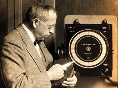
The photograph is unassuming: a middle-aged man in a suit, standing beside a boxy metal instrument roughly the size of a large radio cabinet, circa 1930. The man is Herbert Grove Dorsey. The instrument is the device that came to bear his name — the Dorsey Fathometer — and it represents one of the more consequential, and least remembered, inventions in the history of oceanography.
A Physicist’s Long Road to the Sea
Dorsey was not, by training, an ocean scientist. Born in Kirkersville, Ohio, in 1876, he earned a bachelor’s degree from Johns Hopkins University in 1897 and a Ph.D. from Cornell in 1908, then spent more than a decade teaching physics at the University of Maine, the University of Florida, the University of Rochester, and Cornell. He moved into industry in 1910, working for Western Electric, the National Cash Register Company, and the Hammond Radio Research Laboratory before joining the Submarine Signal Company of Boston in 1922 — a firm that had spent the previous two decades pioneering underwater signaling bells and early sonar for ship navigation.
It was at Submarine Signal that Dorsey turned his attention to a stubbornly old-fashioned problem: measuring the depth of the ocean. For centuries, sailors had done this by paying out a weighted line over the side of a moving ship, waiting for it to hit bottom, and reading off the marked depth — a method that was slow, imprecise in deep water, and required the ship to nearly stop. Dorsey’s insight, building on wartime sonar research, was that a ship could instead send a pulse of sound down through the water and time the echo bouncing back off the seafloor. In 1923 he built a practical version of the device: it fired a sound pulse roughly four times a second and could resolve depths from 8 to 3,000 fathoms — accurate, by contemporary accounts, to within about three inches — all while the ship continued at full speed.
From the 312 to the Instrument That Bore His Name
The Submarine Signal Company began manufacturing commercial echo sounders based on this principle in 1925, marketed under the name “fathometer” and designated the Model 312. Early units used a rotating light and a set of headphones: an operator listened for the returning echo and read the depth off the position of a flashing light on a dial, a method later refined with a neon-tube indicator. It was a marked improvement over the leadline, but it still depended on a human ear and eye working in tandem, which limited both its precision and how continuously it could run.
Dorsey continued refining the design after leaving Submarine Signal in 1925 to join the U.S. Coast and Geodetic Survey as its principal electrical engineer, a post he held through the 1930s. There he built a new version, introduced in 1933, that combined the transmitter and receiver into a single unit called a transceiver, and by 1939 the instrument gained the ability to trace depth automatically onto a paper graph rather than requiring an operator to read a dial — turning a moving ship into a continuous seafloor-mapping platform. In 1934, in recognition of his role in developing it, the Coast and Geodetic Survey formally designated the instrument the “Dorsey Fathometer.”
Why an Instrument Reshaped What We Knew About the Seafloor
The practical effect was enormous. A leadline sounding might take a Survey ship the better part of an hour and required slowing or stopping; a fathometer reading took seconds and could be logged continuously as a vessel steamed along its course. For the first time, a ship could produce a continuous profile of the ocean floor beneath its track rather than a scattering of isolated depth points — the difference between a handful of measurements and something closer to a map. Coast and Geodetic Survey vessels used successive generations of Dorsey’s instrument through the 1930s and beyond to build up the first systematic soundings of large sections of seafloor along the U.S. coast, work that fed directly into nautical charts still used, in updated form, today.
The lineage continued well past Dorsey’s own career. The Submarine Signal Company’s Model 808 fathometer, introduced in 1940, became the standard instrument for shallow-to-intermediate-depth surveying for roughly the next quarter century, and the echo-sounding principle Dorsey helped commercialize remains, in digitized and multibeam form, the basis of virtually all seafloor mapping conducted today, including the systematic surveys that NOAA’s Office of Ocean Exploration and Research still credits to this lineage of Submarine Signal Company and Coast and Geodetic Survey engineers.
Dorsey himself held more than a dozen patents over his career, ranging from telephone apparatus to railway signaling to submarine detection equipment, and he continued that inventive streak within the Survey until his death in 1961. But it is the fathometer — and the deceptively simple insight that sound, timed carefully, could replace a sailor’s weighted rope — that endures as his most lasting contribution, even if his name is now better known to instrument historians than to the public whose coastlines his invention helped chart.
Sources: NOAA Office of Ocean Exploration and Research, “Timeline: The Age of Electronics, 1923–1945” (oceanexplorer.noaa.gov); Engineering and Technology History Wiki, “Fathometer” (ethw.org); Handwiki / Encyclopedia MDPI, “Herbert Grove Dorsey,” biographical entry (encyclopedia.pub); Naval Submarine League Archive, “Submarine Bells to Sonar & Radar: Submarine Signal Company (1901–1946), Part II” (archive.navalsubleague.org).
- NOAA Office of Ocean Exploration and Research, “Timeline: The Age of Electronics, 1923–1945” — oceanexplorer.noaa.gov
- Engineering and Technology History Wiki, “Fathometer” — ethw.org
- Encyclopedia MDPI / HandWiki, “Herbert Grove Dorsey,” biographical entry — encyclopedia.pub
- Naval Submarine League Archive, “Submarine Bells to Sonar & Radar: Submarine Signal Company (1901–1946), Part II” — archive.navalsubleague.org