Columbia Glacier is a tidewater glacier in Prince William Sound on Alaska’s south coast. About 32 miles long and 1,800 feet thick, it flows from the Chugach Mountains to sea level and has been retreating since the early 1980s, among the fastest-moving glaciers in the world.[1]
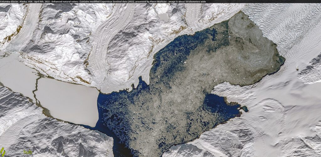
| Type | Tidewater glacier |
|---|---|
| Area | About 400 sq mi (1,000 km²) |
| Length | 32 mi (51 km) |
| Thickness | 1,800 ft (550 m) |
| Retreat since 1982 | 9.9 mi (16 km) |
| Named | 1899, Harriman Alaska Expedition |
Description
The glacier covers about 400 square miles and is 32 miles long. Its head lies in a saddle between Mount Witherspoon and Mount Einstein.[1]
Retreat
Since 1982 the terminus has retreated 16 kilometres (9.9 miles), an average of about 0.6 kilometres a year. At its peak in 2001 the terminus retreated nearly 30 metres a day, and about 500 metres of thinning has occurred at the current terminus position. Further retreat of about 15 kilometres is projected over the next few decades. The source notes that the retreat is not directly forced by climate, but that rapid retreat appears to have been triggered by long-term climate-driven thinning.[1]
Calving and trimline
In 2001 the glacier discharged icebergs at about 7 cubic kilometres a year, and discharge has slowed since. The bald band on the mountainsides, called the trimline, marks a loss of about 400 metres of thickness.[1]
Name
The glacier was named after Columbia University by the 1899 Harriman Alaska Expedition, which named several nearby glaciers after leading American colleges. The Alaska Marine Highway vessel M/V Columbia is named for it.[1]
Size and speed
Columbia Glacier flows from the Chugach Mountains into Prince William Sound, covering about 1,000 square km (400 square miles). It is about 51 km (32 miles) long and up to 550 m (1,800 feet) thick, ends at sea level, and is described as one of the fastest moving glaciers in the world. The main branch begins in a saddle between Mount Witherspoon and Mount Einstein [2].
Name
The Harriman Alaska Expedition named the glacier in 1899 after Columbia University, and also named several nearby glaciers after other elite U.S. colleges. The Alaska Marine Highway vessel M/V Columbia is named after it [2].
Retreat and thinning
Retreat began in the early 1980s. Since 1982 the terminus has retreated about 16 km, averaging roughly 0.6 km per year, and near the current terminus the glacier has thinned by nearly 500 m. In 2001 the terminus retreated at nearly 30 m per day, its peak rate, discharging icebergs at about 7 cubic km per year [2].
Causes and outlook
Advance and retreat of tidewater glaciers is not directly driven by climate, and neighboring tidewater glaciers can advance and retreat at the same time. Rapid retreat appears to be triggered by long-term thinning driven by climate. A 2012 paper in The Cryosphere projected a new stable configuration for the glacier around 2020, with another 15 km of retreat expected until the bed rises above sea level [2].
FAQs
Where is Columbia Glacier? In Prince William Sound, Alaska.
How fast has it retreated? About 16 km since 1982.
Who named it? The 1899 Harriman Alaska Expedition.
How long is Columbia Glacier? About 51 km (32 miles) [2].
How far has it retreated since 1982? About 16 km [2].
Sources
Key facts
- Retreated 16 km since 1982
- 32 miles long
Quick checkHow long is Columbia Glacier?Show answer
About 32 miles
Sources
- Wikipedia. Columbia Glacier (Alaska). 2026 (accessed 2026-11-13)
- Wikipedia. Columbia Glacier (Alaska). 2026 (accessed 2026-11-14)
Editorially reviewed by Specialty Digest Editorial TeamLast reviewed November 13, 2026Researched and drafted with AI assistanceReport an issue