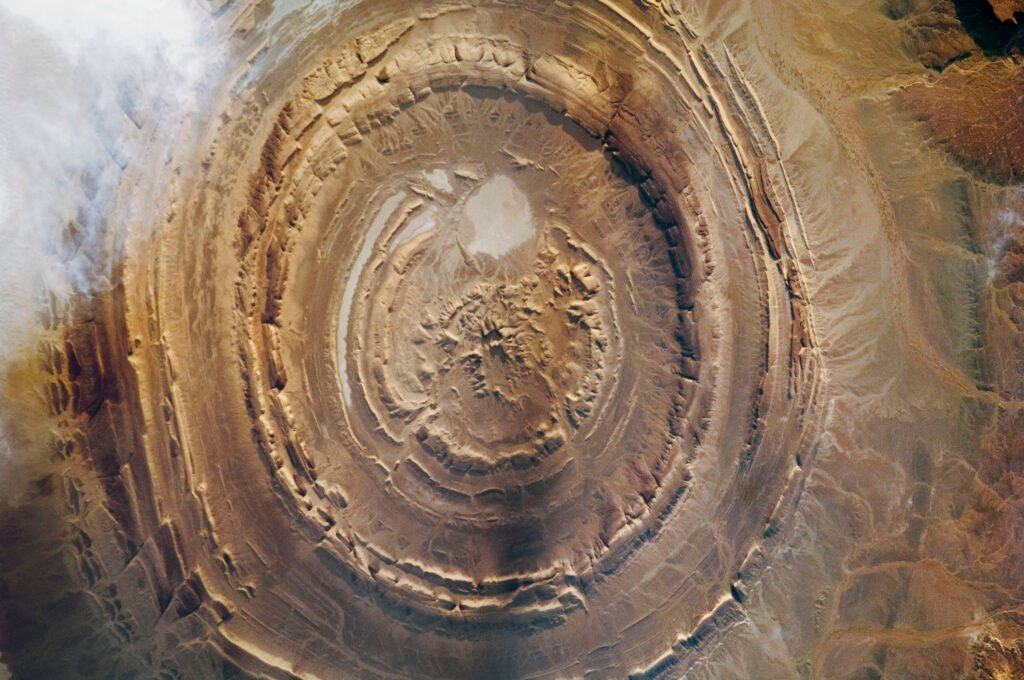
Mauritania is a largely desert country in Northwest Africa, bridging the Arab Maghreb to the north and Sub-Saharan West Africa to the south. Most of its territory lies within the Sahara Desert, and its best known landmark, the Richat Structure, is famous less for what happens on the ground than for how it looks from space.
Where Is Mauritania Located?
Mauritania sits in Northwest Africa on the Atlantic coast, geographically and culturally connecting the Arab Maghreb with Sub-Saharan West Africa.
Geography of Mauritania
Most of Mauritania’s territory lies within the Sahara Desert. Along its Atlantic coastline, Banc d’Arguin National Park protects 1,200,000 hectares of sand dunes, coastal swamps, islands, and shallow waters, and is recognized by UNESCO as one of the world’s most important sites for migratory and wintering birds, hosting an estimated 2 million migratory shorebirds each year from as far away as northern Europe, Siberia, and Greenland. Its waters also support 45 fish species and marine mammals including bottlenose and Atlantic humpback dolphins.
On the Adrar Plateau in the northwest lies the Richat Structure, also called Guelb er Richat or the Eye of the Sahara, a roughly 40 kilometer wide, near perfectly circular geological formation. Peer reviewed geological research describes it not as an impact crater but as a deeply eroded dome formed by uplift over an ancient igneous intrusion and exposed over time by wind erosion into concentric rings of rock.
A Brief History of Mauritania
The medieval trading towns of Ouadane, Chinguetti, Tichitt, and Oualata were founded in the 11th and 12th centuries as caravan route trade hubs and grew into centers of Islamic scholarship and culture through the 16th century, with distinctive courtyard houses and square minaret mosques adapted to desert life and nomadic tradition. UNESCO inscribed the four towns together as the Ancient Ksour of Mauritania in 1996, though they face ongoing threats from desertification and sand drift. Mauritania’s population historically combined Bidhan, or White Moor, Arabic speaking communities descended in part from 11th and 12th century Arab migrations, the Haratin, and Sub-Saharan African groups including Fulani, Soninke, Wolof, and Bambara communities, many settled in the Senegal River valley. France ruled the territory as a colony, and Mauritania became independent on November 28, 1960, joining the United Nations the following year.
Government and Economy
Officially the Islamic Republic of Mauritania, the country operates under a semi presidential system established by its 1991 constitution.
According to the World Bank, Mauritania’s economy has grown at an average of about 3.5 percent a year over the past two decades, built on mining, fishing, gas, and agriculture, with labor force participation below 50 percent. The government has set a goal of reaching upper middle income status by 2050 and has prioritized diversifying into fisheries, renewable energy, and digital services.
Culture and People
Hassaniya Arabic is spoken by the Bidhan population, while Sub-Saharan communities speak Wolof, Soninke, Pulaar, and Bambara, with French widely used as a common administrative language across groups. Mauritania’s population is estimated at around 5.3 million, and Islam is the state religion.
What Is Mauritania Known For?
Mauritania is best known internationally for the Richat Structure, an image that has circulated globally since NASA astronauts on the Gemini IV mission first photographed it in 1965, and which remains a recurring reference image in earth science and space photography precisely because it needs no local context to be instantly recognizable as a satellite image. The Ancient Ksour towns, especially Chinguetti’s historic manuscript libraries, and Banc d’Arguin’s globally significant bird and marine life are Mauritania’s other major points of international recognition.
Why Mauritania Matters
Mauritania matters as a bridge between two distinct regions of Africa, the Arab Maghreb and Sub-Saharan West Africa, a position reflected in its multiethnic population and layered history. Its Ksour towns preserve a specifically Saharan tradition of Islamic scholarship and desert urban design, while Banc d’Arguin underscores how much of the Sahara’s Atlantic coast remains ecologically vital despite the desert that dominates the country’s interior.
Key Takeaways
- Mauritania is a mostly desert country in Northwest Africa, bridging the Arab Maghreb and Sub-Saharan West Africa.
- The Richat Structure, a roughly 40 kilometer wide eroded geological dome, is the country’s most globally recognized landmark, famous since being photographed from space in 1965.
- Banc d’Arguin National Park protects 1,200,000 hectares of coastline and is one of the world’s most important migratory bird habitats.
- The Ancient Ksour towns of Ouadane, Chinguetti, Tichitt, and Oualata were centers of trans-Saharan trade and Islamic scholarship from the 11th century onward.
- Mauritania became independent from France on November 28, 1960.
Sources
- UNESCO World Heritage Centre, “Banc d’Arguin National Park,” https://whc.unesco.org/en/list/506/
- UNESCO World Heritage Centre, “Ancient Ksour of Ouadane, Chinguetti, Tichitt and Oualata,” https://whc.unesco.org/en/list/750
- NASA Science, “Eyeing the Richat Structure,” https://science.nasa.gov/earth/earth-observatory/eyeing-the-richat-structure/
- USGS, “Richat Structure, Mauritania,” https://www.usgs.gov/media/images/richat-structure-mauritania
- US Department of State, Office of the Historian, “Mauritania,” https://history.state.gov/countries/mauritania
- World Bank, “Diversifying the economy: a key lever for sustainable growth in Mauritania,” https://www.worldbank.org/en/news/press-release/2025/11/24/diversifying-the-economy-a-key-lever-for-sustainable-growth-in-mauritania
- UNFPA, World Population Dashboard, Mauritania, https://www.unfpa.org/data/world-population/MR
Key facts
- Most of the country lies within the Sahara Desert, on the Atlantic coast of Northwest Africa3
- The Richat Structure is a roughly 40 kilometer wide eroded geological dome, first photographed from space in 196534
- Banc d'Arguin National Park protects 1.2 million hectares and hosts about 2 million migratory shorebirds a year1
- The Ancient Ksour towns were centers of trans-Saharan trade and Islamic scholarship from the 11th century2
- Independent from France on November 28, 19605
Quick checkWhy is the Richat Structure famous?Show answer
It is a roughly 40 kilometer wide eroded geological dome that became famous after being photographed from space by NASA astronauts in 1965.
Sources
- UNESCO World Heritage Centre. Banc d'Arguin National Park. Undated (accessed 2026-09-28)
- UNESCO World Heritage Centre. Ancient Ksour of Ouadane, Chinguetti, Tichitt and Oualata. Undated (accessed 2026-09-28)
- NASA Science. Eyeing the Richat Structure. Undated (accessed 2026-09-28)
- USGS. Richat Structure, Mauritania. Undated (accessed 2026-09-28)
- US Department of State, Office of the Historian. Mauritania. Undated (accessed 2026-09-28)
- World Bank. Diversifying the economy: a key lever for sustainable growth in Mauritania. 2025 (accessed 2026-09-28)
- UNFPA. World Population Dashboard, Mauritania. 2025 (accessed 2026-09-28)
Editorially reviewed by Specialty Digest Editorial TeamLast reviewed September 28, 2026Researched and drafted with AI assistanceReport an issue