The Trans-Alaska Pipeline System (TAPS) is an 800-mile oil pipeline that carries crude oil from Prudhoe Bay on Alaska’s North Slope south to the ice-free port of Valdez on Prince William Sound. Built between 1974 and 1977 at a cost of more than $8 billion, it is one of the largest private construction projects ever undertaken, and it has delivered billions of barrels of oil while shaping Alaska’s economy, politics and public finances [1][2].
| Length | About 800.3 miles (1,288 km) |
|---|---|
| Diameter | 48 inches |
| Route | Prudhoe Bay to Valdez |
| Highest point | Atigun Pass, 4,739 feet |
| Authorized | Trans-Alaska Pipeline Authorization Act, November 16, 1973 |
| Oil first flowed | June 1977; first barrel at Valdez July 28, 1977 |
| Peak throughput | About 2.03 million barrels per day (1988); single-day high 2,145,297 barrels |
| Construction cost | More than $8 billion |
Why the Pipeline Was Built
The Prudhoe Bay oil discovery of 1968 revealed the largest oil field in North America, but the oil lay on the Arctic coast, far from any ice-free port. A pipeline to Valdez was the chosen solution, but it needed a federal permit that could not be granted until Alaska Native land claims were settled. That obstacle helped lead Congress to pass the Alaska Native Claims Settlement Act in 1971 [3]. Legal barriers were then removed by the Trans-Alaska Pipeline Authorization Act, signed by President Richard Nixon on November 16, 1973, which also granted the right-of-way and provided financial incentives [1].
Route and Design
The pipe is 48 inches in diameter and runs about 800.3 miles from Prudhoe Bay to Valdez, although the straight-line distance between the endpoints is only about 639 miles. The wall is 0.462 inches thick for 466 miles and 0.562 inches thick for 334 miles. The route climbs through the Brooks Range at Atigun Pass, which at 4,739 feet is its highest point, and also passes through the Chugach Mountains near Thompson Pass. It crosses 34 major rivers and streams and nearly 500 minor ones [1].
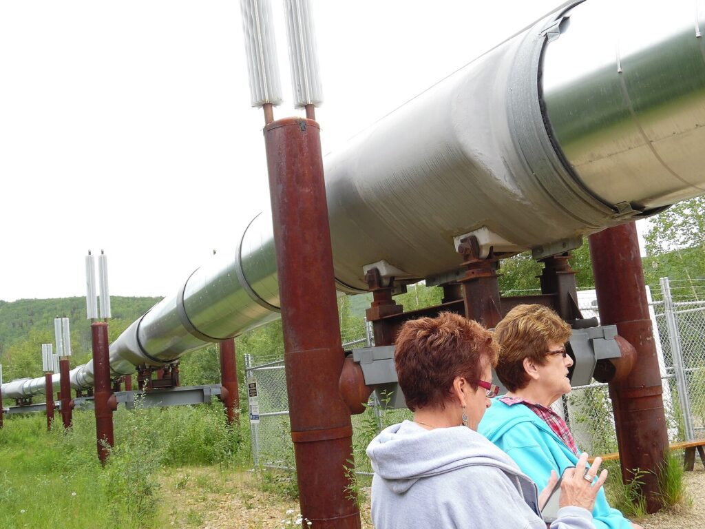
Permafrost made engineers rethink the design. Where the ground was frozen and held large amounts of ice, a buried pipe carrying warm oil would have thawed the soil and sunk. To avoid that, much of the line was raised aboveground on more than 78,000 vertical support members, and insulation of gravel and styrofoam was used in other places, along with raised crossings for caribou and other wildlife [1].
Construction
Preconstruction work took place in 1973 and 1974. Alyeska dates the main construction from March 27, 1975, to May 31, 1977, a span of three years and two months. About 70,000 workers took part in the effort between 1969 and 1977, and 32 Alyeska and contract employees died from construction-related causes [1][4]. The total cost exceeded $8 billion, including the Valdez Marine Terminal and the pump stations [1].
Oil began flowing from Pump Station 1 on June 20, 1977, and reached the Valdez terminal on July 28. The first tanker, the ARCO Juneau, left Valdez on August 1, 1977 [1][4][5]. It was the largest privately funded construction project of its time [4].
Operations and Throughput
The pipeline’s theoretical maximum capacity is about 2.14 million barrels per day, and the throughput peaked at about 2.03 million barrels per day in 1988, with a single-day high of 2,145,297 barrels recorded on January 14, 1988. Since then, production from the North Slope has declined, and current throughput is about 470,000 barrels per day, with flow in recent years hovering just over half a million barrels per day [1]. Lower flow brings technical problems, because slow oil cools more in winter and can freeze. Studies cited in the Wikipedia article estimate a minimum safe flow ranging from about 70,000 to 350,000 barrels per day [1].
The system was designed with 12 pump stations, but only 11 were needed, so the twelfth was never built, and as of December 2024 only four stations were actively moving oil [1][4]. At the southern end, the Valdez Marine Terminal can store 9.18 million barrels in 18 tanks [1].
Ownership
The line is owned by the Alyeska Pipeline Service Company, a consortium of oil companies. Owners have included ConocoPhillips and ExxonMobil since 1970, Unocal from 1970 to 2019, BP from 1970 to 2020, and Hilcorp since 2020, with Williams and Koch Industries holding stakes for periods in the 2000s [1].
Economic Impact
Oil revenue transformed Alaska’s finances. By 1982, petroleum provided 86.5 percent of state revenue, and Alaska moved from having the highest personal income tax in the nation to having none [1]. The Alaska Permanent Fund, created by voters in 1976, requires that at least 25 percent of mineral extraction revenue be deposited, and it has paid annual dividends to residents since 1982 [1][2]. Oil and gas extraction remains the largest source of state revenue [2].
Safety and Spills
The pipeline’s largest mainline spill was about 16,000 barrels in 1978, from a hole caused by sabotage near Fairbanks. The 1989 Exxon Valdez oil spill, which released about 250,000 barrels into Prince William Sound, involved a tanker that had loaded oil at Valdez and was not a failure of the pipeline itself [1][2].
Engineering Against Permafrost
About 420 miles of the line stand above ground on roughly 78,000 vertical support members, and the remaining 380 miles are buried. More than 124,000 heat pipes, also called thermosyphons, carry heat from the ground into the air to keep permafrost stable. The route crosses three mountain ranges, and the steepest grade is 145 percent at Thompson Pass. Air temperatures along the line range from minus 80 to 95 degrees Fahrenheit [4].
Valdez Marine Terminal and Tankers
The terminal covers 1,000 acres and handles crude oil metering, storage, transfer and loading. An average tanker turnaround takes about 22 hours and 20 minutes, from berthing through ballast offloading and loading to departure. All loaded tankers are escorted for more than 70 miles through Prince William Sound into the Gulf of Alaska [4]. By Alyeska’s count the pipeline has moved about 18 billion barrels since 1977, with cumulative milestones of 1 billion barrels in January 1980, 5 billion in September 1986, 10 billion in March 1994 and 15 billion in December 2005. Its highest daily throughput was 2,145,297 barrels on January 14, 1988 [5].
Incidents and Spill Response
The pipeline has faced a handful of serious incidents. Pump Station 8 was destroyed by an explosion and fire on July 8, 1977, killing one person. A sabotage spill at Steele Creek on February 15, 1978, released 16,000 barrels. In 2001 a bullet hole near mile 400 leaked 258,000 gallons, most of which was recovered, and a magnitude 7.9 earthquake along the line on November 3, 2002, caused no spill [5]. After the Exxon Valdez ran aground on March 24, 1989, the Ship Escort/Response Vessel System was established, and it now has more than 42 miles of boom, 100 skimmers and contracts with over 350 fishing vessels. Three leak-detection systems are monitored from an operations control center in Anchorage, which can stop and isolate the flow in 15 minutes, and 71 gate valves can block oil in either direction [4][5].
Ownership Changes
BP announced the sale of its Alaska operations, including its pipeline interest, to Hilcorp in August 2019, and the sale of the pipeline ownership to Harvest Alaska was finalized in December 2021 [5].
FAQs
How long is the Trans-Alaska Pipeline? About 800 miles, from Prudhoe Bay to Valdez.
When did the pipeline open? Oil began flowing in June 1977, and the first barrel reached Valdez on July 28, 1977.
How much oil does it carry now? Current throughput is about 470,000 barrels per day, far below the 1988 peak of about 2.03 million.
Why is part of the pipeline above ground? Aboveground sections prevent warm oil from thawing permafrost and destabilizing the line.
Who owns the pipeline? The Alyeska Pipeline Service Company, a consortium of oil companies that has included ConocoPhillips, ExxonMobil, BP and Hilcorp.
Sources
- Wikipedia: Trans-Alaska Pipeline System
- Encyclopaedia Britannica: Alaska
- Wikipedia: Alaska Native Claims Settlement Act
- Alyeska Pipeline Service Company: Fact Tidbits
- Alyeska Pipeline Service Company: Since Start-Up
Key facts
Quick checkWhere does the Trans-Alaska Pipeline end?Show answer
Valdez, on Prince William Sound
Sources
- Wikipedia. Trans-Alaska Pipeline System. 2026 (accessed 2026-11-11)
- Encyclopaedia Britannica. Alaska. 2026 (accessed 2026-11-11)
- Wikipedia. Alaska Native Claims Settlement Act. 2026 (accessed 2026-11-11)
Editorially reviewed by Specialty Digest Editorial TeamLast reviewed November 11, 2026Researched and drafted with AI assistanceReport an issue