The Good Friday earthquake, also called the Great Alaska earthquake, struck southcentral Alaska at 5:36 p.m. on March 27, 1964. With a moment magnitude of about 9.2, it is the most powerful earthquake ever recorded in North America and the second most powerful recorded anywhere since 1900. Shaking lasted 4 minutes and 38 seconds, and the quake and the tsunamis it generated caused deaths and damage across Alaska and along the Pacific coast as far as California [1][2].
| Date and time | March 27, 1964, 5:36 p.m. Alaska Standard Time |
|---|---|
| Magnitude | Mw 9.2 |
| Duration | 4 minutes 38 seconds |
| Epicenter | Near College Fjord, Prince William Sound |
| Fault | Aleutian megathrust |
| Rupture length | About 600 miles (970 km) |
| Deaths | About 139, most from tsunamis |
| Property damage | About $116 million (1964 dollars) |
The Earthquake
The epicenter lay near College Fjord in Prince William Sound, about 78 miles east of Anchorage and 40 miles west of Valdez, at a depth of roughly 15 miles. The earthquake was a megathrust event on the Aleutian subduction zone, where the Pacific plate slides beneath the North American plate. About 600 miles of the fault ruptured, with slip of up to 60 feet, releasing roughly five centuries of accumulated stress [1].
The maximum intensity reached X (Extreme) on the Modified Mercalli scale, and the shaking lasted 4 minutes and 38 seconds. Alaska stands among the most seismically active regions on Earth, and Britannica notes that the 1964 earthquake was among the most powerful recorded in the United States [1][3].
Casualties
The earthquake and the tsunamis it caused killed about 139 people, of whom 15 died from the quake itself and 124 from tsunamis in Alaska, Oregon and California. Other sources give a slightly lower figure, with the main Wikipedia article on Alaska giving 133 deaths [1][2]. Valdez lost 32 people in an underwater landslide at the harbor and docks. At Chenega, a 27-foot tsunami killed 23 of the village’s 68 residents. Five people died on the Oregon coast, including four children camping at Beverly Beach State Park, and 13 died in California, mostly at Crescent City [1].
Damage in Anchorage and Other Communities
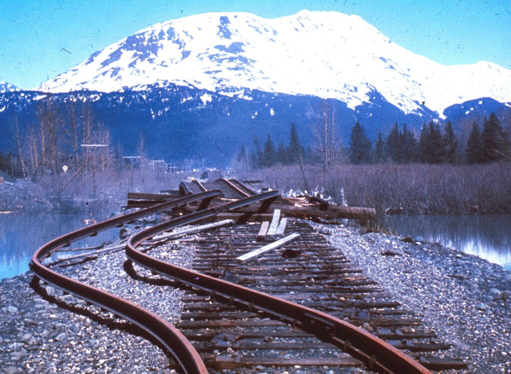
Most of the damage occurred in Anchorage, about 75 miles northwest of the epicenter, where landslides in clay bluffs near Knik Arm and Cook Inlet destroyed the Turnagain neighborhood and its roughly 75 homes. That site is now Earthquake Park. The school at Government Hill split into two pieces, and the airport control tower collapsed [1].
Elsewhere, Valdez was not fully destroyed, but after three years the community relocated about four miles west to higher ground. Seward, Whittier and Kodiak were heavily damaged by shaking, subsidence, tsunamis and fires. At Cordova, the Million Dollar Bridge over the Copper River lost a span. Subsidence of up to eight feet let tidewater flood Girdwood and Portage, and Girdwood was relocated inland while Portage was abandoned. About 20 miles of the Seward Highway had to be rebuilt [1].
Ground Changes
The earthquake permanently changed the landscape. Montague Island rose 43 to 49 feet, and areas near Kodiak rose about 30 feet, while an area of about 110,000 square miles subsided, including much of the Kenai Peninsula [1].
Tsunamis
The largest wave, about 220 feet high, struck Shoup Bay near Valdez. Most of the tsunami damage in Alaska came from about 20 smaller local waves triggered by landslides rather than from the main tectonic wave. Effects were recorded in more than 20 countries, including Japan, Peru, New Zealand and Antarctica, and tide gauges even registered motion at Freeport, Texas [1].
In Crescent City, California, an estimated $7.4 million in damage destroyed 30 blocks of the town [1].
Response and Recovery
The U.S. military restored communications, deployed troops and airlifted about 2.57 million pounds of supplies. President Lyndon B. Johnson declared all of Alaska a major disaster area the day after the quake. Broadcaster Genie Chance coordinated public information for more than 24 hours, and the Army Corps of Engineers spent $110 million on roads, debris removal and new townsites [1]. The Engineering and Geological Evaluation Group, led by geologist Ruth A. M. Schmidt, issued its report on May 8, 1964 [1].
In the first day there were 11 aftershocks of magnitude 6.0 or greater, followed by nine more over the next three weeks and thousands in total [1].
Scientific Legacy
The earthquake gave scientists a detailed record of a great subduction-zone event and became a landmark in the acceptance of plate tectonics. The disaster also led to the creation of the West Coast and Alaska Tsunami Warning Center, which monitors the Pacific for tsunamis today [1][2].
Why the Earthquake Was So Large
Great earthquakes occur where one tectonic plate dives beneath another, and the Alaska-Aleutian margin is one of the most active of these boundaries. Along the Aleutian megathrust the Pacific plate descends beneath the North American plate, and strain builds up for centuries until a long segment of the fault slips all at once. In 1964 the fault moved as a reverse fault along about 600 miles, which is why the rupture was long enough to produce such a large magnitude and such a long period of shaking [1]. Estimates of peak ground acceleration were modest for a quake of this size, in the range of 0.14 to 0.18 g, but the long duration allowed landslides and liquefaction to do enormous damage [1].
Key Numbers at a Glance
The scale of the event is easiest to grasp through its numbers. The earthquake had a magnitude of 9.2 or 9.3 depending on the estimate. It ruptured about 600 miles of fault and shifted the ground over roughly 110,000 square miles. Property damage was put at about 6 million in the 1964 dollars used in the article, and the Army Corps of Engineers alone spent 0 million on roads, debris removal and new townsites. Eleven aftershocks of magnitude 6.0 or greater occurred within the first day [1]. A missile-detection radar at Clear Air Force Station was knocked offline for six minutes, a reminder of how closely Alaska’s military role was tied to the event [1].
Remembering the Earthquake Today
The event remains a defining moment in Alaska’s modern history, five years after statehood. In Anchorage, the site of the Turnagain neighborhood is now Earthquake Park. Valdez, rebuilt on a new site, and communities such as Girdwood stand as reminders of how the disaster reshaped the map [1]. The West Coast and Alaska Tsunami Warning Center, created in response to the disaster, continues to protect Pacific coasts [1][2].
FAQs
When was the Good Friday earthquake? March 27, 1964, at 5:36 p.m. Alaska Standard Time.
How strong was the 1964 Alaska earthquake? It had a moment magnitude of about 9.2, the strongest ever recorded in North America.
How long did the shaking last? Four minutes and 38 seconds.
How many people died? About 139 people died according to Wikipedia’s earthquake article, most from tsunamis. Some sources give slightly lower totals.
What came out of the disaster? The West Coast and Alaska Tsunami Warning Center, extensive rebuilding and major advances in understanding subduction-zone earthquakes.
Sources
More in Earth Sciences
Key facts
Quick checkWhat was the magnitude of the 1964 Alaska earthquake?Show answer
About 9.2
Sources
- Wikipedia. 1964 Alaska earthquake. 2026 (accessed 2026-11-11)
- Wikipedia. Alaska. 2026 (accessed 2026-11-11)
- Encyclopaedia Britannica. Alaska. 2026 (accessed 2026-11-11)
Editorially reviewed by Specialty Digest Editorial TeamLast reviewed November 11, 2026Researched and drafted with AI assistanceReport an issue