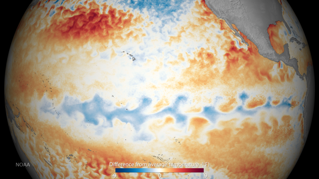
La Nina is the cooler counterpart to El Nino, part of the El Nino-Southern Oscillation (ENSO) cycle that governs much of the planet’s year-to-year climate variability. It occurs when sea surface temperatures across the central and eastern tropical Pacific Ocean drop below their long-term average, typically by half a degree Celsius or more, sustained over several consecutive months. The event reorganizes atmospheric circulation across the globe, intensifying trade winds, deepening the usual temperature gradient across the Pacific basin, and shifting the position of major rainfall belts. Meteorologists and climatologists monitor La Nina closely because its effects extend far beyond the ocean where it originates, reaching agriculture, water supply, and emergency planning on every inhabited continent.
The name comes from Spanish-speaking fishing communities along the South American coast, who noticed the opposite pattern to El Nino’s warm waters and informally called the cooling phase “the girl” to distinguish it from “the boy.” Today the term is used by national weather agencies worldwide, including the U.S. National Oceanic and Atmospheric Administration, as an official designation within the ENSO framework. La Nina episodes typically last nine to twelve months, though some multi-year events have persisted for two to three years, as seen in the 2020-2023 “triple-dip” La Nina that affected global weather patterns for an unusually long stretch.
How La Nina Forms
Under normal conditions, trade winds blow from east to west across the tropical Pacific, piling up warm surface water near Indonesia and allowing cooler water to well up along the coast of South America. During La Nina, these trade winds strengthen beyond their usual intensity, pushing even more warm water toward the western Pacific and intensifying the upwelling of cold, nutrient-rich water in the east. This self-reinforcing feedback loop, first described through coupled ocean-atmosphere models in the late twentieth century, can lock the Pacific into a La Nina state for months at a time before the system eventually relaxes back toward neutral or warm conditions.
Scientists track La Nina through several standardized indices, most notably the Oceanic Nino Index, which measures three-month running average sea surface temperature anomalies in a specific equatorial Pacific region. When this index drops below negative 0.5 degrees Celsius for five consecutive overlapping three-month periods, the event is officially classified as La Nina. Satellite altimetry, moored ocean buoys, and autonomous Argo floats all feed data into these monitoring systems, giving forecasters several months of lead time to anticipate the broader climate shifts that typically follow.
Global Weather Impacts
La Nina tends to produce wetter-than-average conditions across Australia, Indonesia, and parts of Southeast Asia, while bringing drier conditions to the southern United States, parts of South America, and East Africa. In North America, it is strongly associated with a more active Atlantic hurricane season, because the weaker wind shear typical of La Nina years allows tropical storms to organize and intensify more easily. The southern and southwestern United States frequently experience drought during La Nina winters, a pattern that has repeatedly stressed water reservoirs in California and the Colorado River Basin.
In the Pacific Northwest and parts of Canada, La Nina winters tend to bring colder temperatures and heavier mountain snowpack, which can be beneficial for spring water supply even as it complicates winter transportation. South Asia generally sees a stronger monsoon during La Nina years, which can boost agricultural output in India but also raises flood risk in low-lying river basins. These shifting patterns illustrate why La Nina is considered a global climate driver rather than a purely regional ocean phenomenon.
Effects on Agriculture and Food Security
Because La Nina reliably alters rainfall distribution, it has an outsized influence on global commodity markets. Soybean and corn production in Argentina and southern Brazil often suffers during La Nina due to reduced rainfall, while wheat yields in Australia can improve thanks to wetter growing seasons. Agricultural economists and commodity traders watch ENSO forecasts closely each year, since a strong La Nina can shift global grain price expectations months before harvest.
Smallholder farmers in drought-prone regions of East Africa and Central America are particularly vulnerable, since La Nina’s drying effect can compound existing food security challenges. International organizations, including the Food and Agriculture Organization, incorporate ENSO forecasts into early warning systems that help governments pre-position food aid and adjust planting recommendations before a La Nina-driven drought fully develops.
Distinguishing La Nina From El Nino
El Nino and La Nina are often described as opposite phases of the same oscillation, but their impacts are not simple mirror images. El Nino generally suppresses Atlantic hurricane activity while La Nina enhances it; El Nino tends to bring wetter winters to the southern United States while La Nina brings drier ones. The transition between phases, sometimes called ENSO-neutral, can last anywhere from a few months to over a year, during which neither pattern dominates.
Climate scientists continue to study how a warming global climate may be altering the frequency, strength, or duration of La Nina and El Nino events. Some research suggests that extreme La Nina and El Nino events could become more common as ocean temperatures rise, though this remains an active area of investigation with ongoing refinement of climate models.
FAQ
How long does a typical La Nina event last?
Most La Nina events last nine months to a year, though some, including the 2020-2023 episode, have persisted for two to three years in a row.
Does La Nina cause more hurricanes?
Yes, La Nina is generally associated with a more active Atlantic hurricane season because reduced wind shear allows storms to form and strengthen more easily.
Is La Nina becoming more frequent due to climate change?
Research is ongoing, but some studies suggest that extreme La Nina and El Nino events may become more frequent as global ocean temperatures continue to rise.
More in Climate & Weather
Editorially reviewed by Specialty Digest Editorial TeamLast reviewed November 4, 2026Researched and drafted with AI assistanceReport an issue