Cheaha Mountain is the highest point in Alabama, rising about 2,407 feet above sea level in the Talladega Mountains of the eastern part of the state. It is the centerpiece of Cheaha State Park, which covers 2,799 acres in Clay and Cleburne counties and is surrounded by the Talladega National Forest [1][2]. Some sources list the elevation as 2,413 feet because of different survey values [3]. This entry covers the mountain’s name, geography, the park built around it, the trails and the best ways to visit.
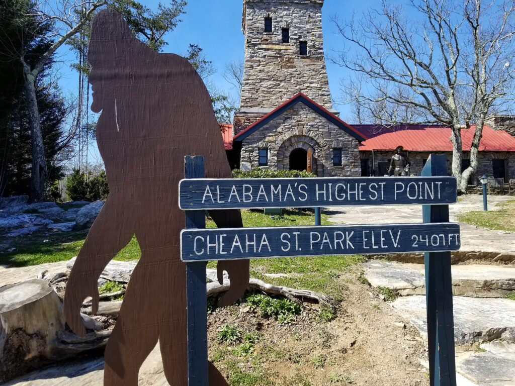
| Elevation | About 2,407 feet (some sources: 2,413 feet) |
|---|---|
| Location | Clay and Cleburne counties, east-central Alabama |
| Range | Talladega Mountains |
| State park area | 2,799 acres |
| Park opened | 1933; construction completed 1939 |
| Name origin | Creek “chaha,” meaning “high place” |
Name and meaning
The name Cheaha comes from the Creek word chaha, which is usually translated as “high place.” The Muscogee (Creek) people lived and hunted in this part of the Southeast long before European settlers arrived, and the name fits the mountain’s role as the tallest feature in the area. The same word appears in other place names around the mountain [1][2]. For the roots of Alabama’s own name in Native languages, see Etymology of the Name Alabama.
Geography and geology
Cheaha Mountain lies in the Talladega Mountains, which are the southernmost part of the Blue Ridge, the long chain that runs northeast through the Appalachians. The mountain rises well above the surrounding Piedmont foothills, and on a clear day the view from its summit extends for many miles. The elevation difference makes the mountain cooler than the lowlands, which supports forests of hardwoods and pines [3].
Hard, erosion-resistant rock, including quartzite, helps hold the mountain up while softer rocks nearby wear away more quickly. Exposed rock faces and boulder fields on the slopes show this geology to hikers. The wider setting is described in the main Alabama profile, and the rocks that serve as state emblems are covered in Alabama State Rock, Mineral, Gemstone, Fossil, Shell and Soil.
History of Cheaha State Park
The state acquired the land in the early 1930s, and the park first opened to the public in 1933. It is described as Alabama’s oldest continuously operating state park. As part of the New Deal, the Civilian Conservation Corps, a federal work program of the Great Depression, built many of the original structures. Crews hand-dug the six-acre Cheaha Lake and constructed stone cabins, a stone bathhouse, pavilions, a group lodge and the Bunker Tower. Construction was finished in 1939, when the park held an official opening celebration [1][2].
Bunker Tower and Bald Rock
Bunker Tower, an observation tower of local stone, sits on the summit and offers wide views from its deck, which is reached by an interior stairway. It opened in the 1930s and once housed a gift shop and rooms for fire watchers. Nearby, Bald Rock is an exposed rock face with an open view, reached by a quarter-mile wooden walkway that is accessible to wheelchair users [1][2].
Trails and recreation
The park offers short forest walks as well as longer hikes. A section of the Pinhoti Trail, a 100-mile route that links to the long-distance trail network of the Appalachians, passes through the park. The Pulpit Rock Trail leads to a quartzite cliff that is popular with climbers, and the Rock Garden Trail is a strenuous hike with more than 1,000 feet of elevation change. Mountain bikers use the Cheaha Express Trail, which hosts an annual race, and Cheaha Lake has a swimming beach, paddle boats and bass and bluegill fishing [1].
Lodging and facilities
Visitors can stay at Cheaha Lodge, a hotel built in 1973 that has 30 rooms, a pool and a dining room with forest views, or in stone cabins and chalets. The park has dozens of campsites, including sites with hookups for recreational vehicles and primitive sites near the lake. The Bald Rock Group Lodge is used for conferences and weddings [1][2].
Visiting tips
The mountain is open year-round, but conditions change with the seasons. Spring brings wildflowers, summer is warm but cooler than the lowlands, autumn brings colorful foliage, and winter can bring ice. Since fees, hours and trail conditions change, visitors should check with the park before they go. Hunting is not allowed in the park, though it is permitted in parts of the adjacent national forest under state rules [2].
Place among Alabama’s symbols
As the state’s highest point, Cheaha is often the first thing mentioned in lists of Alabama landmarks. It is part of a landscape that includes the longleaf pine forests described in Southern Longleaf Pine (Alabama State Tree) and the broader network of Alabama State Symbols [1].
Climate and plant life
Because of its height, Cheaha has a cooler and often wetter climate than the lowlands around it, and fog and light frost are more common in the cold season. Forests on the slopes include oaks, hickories and pines, with mountain laurel and wildflowers in the understory. The park lies inside a much larger national forest, which protects a continuous block of woodland that provides habitat for deer, wild turkey, songbirds and many smaller animals. Keeping that habitat connected is one reason the area is valued by conservation groups and hikers alike [1][3].
Visitors who want to understand the area in context can compare Cheaha with Alabama’s other regions, from the Tennessee Valley to the Gulf coast, using the geography section of the state profile. The difference in elevation between the highest point and the sea-level coast is about 2,400 feet, a modest figure by national standards but notable in a state that is mostly low and rolling [3].
FAQs
How high is Cheaha Mountain? About 2,407 feet according to the Encyclopedia of Alabama; some surveys give 2,413 feet.
Where is Cheaha Mountain? In Clay and Cleburne counties in east-central Alabama.
What does Cheaha mean? It comes from a Creek word meaning “high place.”
Who built Cheaha State Park? The Civilian Conservation Corps built many of the original structures in the 1930s.
Is Cheaha the oldest state park in Alabama? It is described as Alabama’s oldest continuously operating state park.
Sources
- Encyclopedia of Alabama: Cheaha State Park
- Alabama Living: Cheaha State Park: The closest thing to heaven in the state of Alabama
- Earth@Home: Alabama Earth Science Quick Facts
More in Earth Sciences
Key facts
Quick checkHow high is Cheaha Mountain?Show answer
About 2,407 feet above sea level, according to the Encyclopedia of Alabama (some sources give 2,413 feet).
Sources
- Encyclopedia of Alabama. Cheaha State Park. n.d. (accessed 2026-11-10)
- Alabama Living. Cheaha State Park: The closest thing to heaven in the state of Alabama. n.d. (accessed 2026-11-10)
- Earth@Home. Alabama Earth Science Quick Facts. n.d. (accessed 2026-11-10)
Editorially reviewed by Specialty Digest Editorial TeamLast reviewed November 10, 2026Researched and drafted with AI assistanceReport an issue