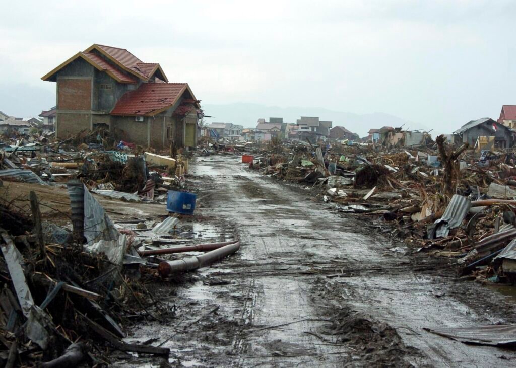
The 2004 Indian Ocean earthquake and tsunami was a magnitude 9.1 undersea earthquake off the west coast of Sumatra, Indonesia, on 26 December 2004, followed by tsunami waves that struck coastlines around the Indian Ocean. The United Nations has estimated that about 227,000 people were killed in fourteen countries, making it the deadliest tsunami in recorded history.
Background to the earthquake
The earthquake occurred in the Ring of Fire, the belt of intense seismic and volcanic activity around the Pacific Ocean, where about 80 percent of the world’s earthquakes happen, according to the Norwegian seismology institute NORSAR. The rupture lay in a subduction zone, a boundary where one tectonic plate slides beneath another. Here the Indian Plate is pushed under the Burma Plate, a process described under plate tectonics.
The Australian Institute for Disaster Resilience gives the epicenter as about 30 kilometers below the seabed and roughly 250 kilometers south-southwest of Banda Aceh, in the province of Aceh in Indonesia. NORSAR describes it as about 160 kilometers west of Sumatra.
Course of events
The earthquake struck at 00:58:53 UTC on Sunday 26 December 2004, which was just before 8 a.m. local time in Sumatra. NORSAR calls it the strongest earthquake in 40 years, and within about ten minutes the crust ruptured over an area of roughly 1,500 kilometers. In the nine hours that followed, fourteen aftershocks with magnitudes between 5.7 and 7.3 occurred along the arc from Sumatra toward the Nicobar and Andaman Islands. NORSAR gives the largest as magnitude 7.1, so published figures differ slightly.
The sea floor moved so much that the whole water column, from seabed to surface, was set in motion, NORSAR explains, and this is what produced the tsunami. The institute says the waves grew to as much as 30 meters when they reached shallow water.
Within 15 minutes waves began hitting the northern coast of Sumatra and the Nicobar Islands. In Aceh, which was hit hardest in Indonesia, waves of up to 30 meters were recorded, and in Banda Aceh the water surged about two kilometers inland. About two hours after the earthquake the tsunami reached Sri Lanka, India and Thailand. The Maldives were struck an hour later. More than seven hours after the earthquake, the waves were observed at Mauritius and along the east coast of Africa. In shallow water the waves could move at about 80 kilometers per hour, the Australian institute reports, and the largest effects were felt in Indonesia and Sri Lanka.
Aftermath and casualties
Counting the dead was difficult, and estimates differ. The United Nations figure is about 227,000 people killed in fourteen countries. Data published by the Tsunami Evaluation Coalition indicated that at least 275,000 people died, and NORSAR cites more than 230,000. Many people swept away were never accounted for.
The Australian institute lists the worst affected countries as India, Indonesia, Malaysia, the Maldives, Myanmar, Sri Lanka, Seychelles, Thailand and Somalia. Measured in lives lost, it describes the event as one of the ten worst earthquakes in recorded history and the single worst tsunami.
The economic damage was severe. In the Maldives, financial losses were about 45 percent of gross domestic product. In Indonesia, losses were equal to the entire economic output of Aceh Province, and the disaster lowered the country’s projected growth by about 0.2 percent in 2005. The tsunami destroyed towns, homes, livelihoods and infrastructure and displaced thousands of people. International aid followed, and the Australian government alone committed more than $1 billion to relief and reconstruction, the institute reports.
International response
The scale of the disaster prompted one of the largest relief efforts on record. The Australian Institute for Disaster Resilience reports that Australia became the largest per capita contributor of tsunami aid and played a major role in reconstruction, particularly in Indonesia. The Australian government committed more than $1 billion, and the Australian public raised about $235 million to help survivors. Twenty-six Australians lost their lives in the disaster.
The institute also notes that the tsunami wrecked coastal areas, displaced thousands of people and destroyed infrastructure and livelihoods in many countries at once, which made coordination between governments and aid agencies a central challenge of the recovery.
Significance and legacy
The disaster showed how a single earthquake can harm many countries at once, and it changed how governments think about tsunami warnings. NORSAR reports that warning systems for earthquakes and tsunamis have improved significantly since 2004 and that technology now makes it possible to monitor events more precisely and send real-time alerts. After the disaster, seismic and hydroacoustic data from the monitoring network of the Comprehensive Nuclear-Test-Ban Treaty Organization were made available to national tsunami warning centers in 2006, and the data now arrive in real time.
NORSAR points to the 2011 earthquake and tsunami near Fukushima in Japan, where about 19,000 lives were lost, as a later test of these systems. A warning was issued there just three minutes after the earthquake, which saved many lives. NORSAR adds that large tsunamis of this kind are rare but do occur. Even so, earthquakes still cannot be predicted, NORSAR stresses, and a timely evacuation remains difficult even with better warnings. Earlier tsunami disasters include the 1755 Lisbon earthquake and the 1883 eruption of Krakatoa. This is why the 2004 event is a central example in studies of disaster preparedness, which covers planning, public education and evacuation.
The scale of the earthquake is usually described with the moment magnitude scale. NORSAR explains that the monitoring network was built to detect nuclear test explosions, and that Norway runs its stations as the national data center. The Australian institute adds that, across the region, some people believed to have been swept away have never been accounted for, which is one reason the death toll is still given as a range.
More in Earth Sciences
Key facts
- The earthquake had a magnitude of 9.1 and struck off the west coast of Sumatra at 00:58:53 UTC on 26 December 2004.1
- The United Nations estimated about 227,000 deaths in fourteen countries, while the Tsunami Evaluation Coalition indicated at least 275,000.1
- Waves reached northern Sumatra within 15 minutes, Sri Lanka, India and Thailand after about two hours, and East Africa after more than seven hours.1
- Waves in Aceh reached up to 30 meters, and the water surged about two kilometers inland at Banda Aceh.12
- The earthquake occurred where the Indian Plate is pushed beneath the Burma Plate.2
- Warning systems have improved since 2004, and data from a global monitoring network reached tsunami warning centers in real time from 2006.2
Related concepts
Quick checkHow many countries were hit by the 2004 Indian Ocean tsunami?Show answer
The United Nations estimated that about 227,000 people were killed in fourteen countries, with Indonesia, Sri Lanka, India and Thailand among those most affected.
Sources
- Australian Institute for Disaster Resilience, Indian Ocean tsunami, 2004 (Australian Disasters), https://knowledge.aidr.org.au/resources/tsunami-indian-ocean-boxing-day-tsunami-2004/
- NORSAR, 20 years since the Sumatra-Andaman earthquake and the deadly tsunami (2024), https://www.norsar.no/news/20-years-since-the-sumatra-andaman-earthquake-and-the-deadly-tsunami
Editorially reviewed by Specialty Digest Editorial TeamLast reviewed November 4, 2026Researched and drafted with AI assistanceReport an issue