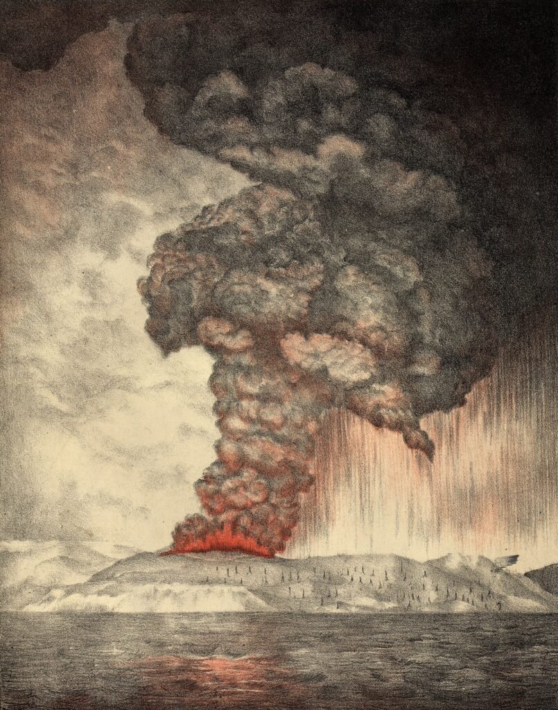
The 1883 eruption of Krakatoa was a catastrophic volcanic explosion in the Sunda Strait, between the Indonesian islands of Java and Sumatra, that reached its peak on 26 and 27 August 1883. It destroyed most of Krakatau Island and killed about 36,000 people, mostly in tsunamis that struck nearby coasts. The blast was heard thousands of kilometers away, and its ash dimmed skies and lowered global temperatures for several years.
Background to the 1883 eruption
Krakatau, which English writers often spell Krakatoa, is a volcano in the Sunda Strait, in what is now Indonesia. The Smithsonian and USGS description reproduced by Oregon State University’s Volcano World says an earlier volcano here collapsed, perhaps in 416 AD, leaving a caldera about 7 kilometers wide. A caldera is the large basin that forms when a volcano’s summit falls into its emptied magma chamber. Verlaten and Lang islands are remnants of that older volcano.
Three later cones, named Rakata, Danan and Perbuwatan, grew inside the old caldera and merged into the island that existed before 1883. For at least two centuries this island had no recorded eruptions, according to the National Centers for Environmental Information (NCEI) of the U.S. National Oceanic and Atmospheric Administration (NOAA).
That changed in early May 1883, when the captain of the German warship Elisabeth saw a cloud of ash and dust rising above the uninhabited island. Over the next two months, commercial and sightseeing ships reported similar displays, with loud explosions, churning black clouds and glowing ash and pumice. Scientific expeditions visited, and people on neighboring Java and Sumatra were so impressed that a near-festive mood developed. Only later did they learn these displays had been a prelude to one of the largest eruptions in history.
Course of the eruption
On 26 August 1883, following a series of explosions, a colossal eruption began. A 1983 USGS bulletin by Tom Simkin and Richard Fiske describes a period of about 23 hours, across 26 and 27 August, in which more than 4 cubic miles of volcanic debris exploded upward. NOAA gives a slightly higher figure of as much as 5 cubic miles, or 21 cubic kilometers, so published estimates differ somewhat.
During the most violent explosion, NOAA reports, ash rose about 80 kilometers into the sky and blanketed roughly 800,000 square kilometers, bringing darkness for two and a half days. The northern two-thirds of the island collapsed beneath the sea, leaving a caldera about 6 kilometers wide. Only a remnant of Rakata survived. The collapse also produced pyroclastic flows, which are fast, ground-hugging mixtures of hot rock fragments, pumice and ash. Oregon State University notes that pyroclastic surges crossed about 40 kilometers of the Sunda Strait and reached the Sumatra coast.
The final explosion made what NOAA calls the loudest sound recorded in modern history, heard across more than 10 percent of Earth’s surface. People in Australia and on the island of Mauritius, more than 4,600 kilometers away, reported noises like distant gunfire. Pressure waves traveled several times around the globe, and instruments in Great Britain and the United States recorded sudden spikes.
The tsunamis did the greatest harm. The largest wave recorded in Banten province was estimated at 41 meters high, and the smaller waves that followed destroyed 165 nearby settlements. Waves were detected as far away as Hawaii and South America.
Aftermath of the Krakatoa eruption
NOAA puts the death toll at approximately 36,000 and says more than 34,000 of these deaths were caused by tsunamis. The USGS bulletin and Oregon State University also give more than 36,000. Hundreds of coastal towns and villages on Java and Sumatra were destroyed, and vegetation on the surrounding islands was stripped bare.
The effects reached far beyond Indonesia. Ash drifted around the world and produced halos around the Moon and Sun. It also filtered sunlight, and NOAA states that global temperatures fell by as much as 0.5 degrees Celsius (0.9 degrees Fahrenheit) in the year after the eruption. Temperatures did not return to normal until 1888. The USGS bulletin likewise notes that phenomena linked to the eruption were recorded around the world and lingered for several years.
Significance and legacy
NOAA describes Krakatau as the first scientifically well-recorded volcanic eruption. Scientists organized expeditions to document the volcano and collect rock samples, and the observations later helped researchers studying how life recolonizes devastated and newly formed landscapes, such as the area around Mount St. Helens in the United States. News of the disaster spread quickly because a worldwide telegraph network had recently been installed.
Oregon State University rates the eruption as VEI 6, a measure of explosive size, and calls it the second largest in Indonesia during historical time. It also stands among the deadliest volcanic disasters on record.
The volcano did not stay quiet. After less than half a century, a new cone called Anak Krakatau, meaning Child of Krakatau, rose inside the 1883 caldera, and it has erupted often since 1927. On 22 December 2018 an eruption there set off a tsunami that, according to NOAA, produced waves above 80 meters on nearby islands, killed at least 437 people, injured more than 30,000 and displaced more than 30,000 others. Anak Krakatau lost about two-thirds of its volume in that event yet kept growing, and it erupted again on 10 April 2020 without widespread damage.
The 1883 disaster remains a reference point for scientists who study explosive eruptions, tsunami hazards and the way volcanic ash can change weather and climate on a global scale. Another catastrophic tsunami struck Indonesian coasts in 2004, and it is described in the entry on the 2004 Indian Ocean earthquake and tsunami.
Anak Krakatau since 1883
Oregon State University’s summary says Anak Krakatau has been the site of frequent eruptions since 1927. One tourist was killed and five were injured by an explosion there in 1993. A scientific visit in 1997 found quiet periods lasting at least a couple of days, interrupted by stretches of nearly continuous eruption, with minor ash emissions, a few volcanic bombs and occasional larger explosions that produced volcanic lightning.
When a group of scientists visited in January 1960, they measured the young island at about 1.5 kilometers across and 166 meters tall, and they saw explosive eruptions throwing out fragments from ash to boulders in size. The 2018 tsunami showed that eruptions at the young island can still endanger nearby coasts.
More in Earth Sciences
Key facts
- The main eruption of Krakatau took place on 26 and 27 August 1883 in the Sunda Strait between Java and Sumatra.1
- About 36,000 people died, and more than 34,000 of those deaths were caused by tsunamis.1
- The northern two-thirds of Krakatau Island collapsed into the sea, leaving a caldera about 6 kilometers wide.1
- Ash rose about 80 kilometers high, and global temperatures fell by as much as 0.5 degrees Celsius in the following year.1
- The final explosion was heard in Australia and Mauritius, more than 4,600 kilometers away.1
- A new volcanic cone, Anak Krakatau, has grown inside the caldera and has erupted often since 1927.2
Related concepts
Quick checkHow many people died in the 1883 eruption of Krakatoa?Show answer
About 36,000 people died, according to NOAA, and more than 34,000 of those deaths were caused by the tsunamis rather than by the explosion itself.
Sources
- NOAA National Centers for Environmental Information, On This Day: Historic Krakatau Eruption of 1883, https://www.ncei.noaa.gov/news/day-historic-krakatau-eruption-1883
- Oregon State University, Volcano World: Krakatau (description from the Smithsonian and USGS), https://volcano.oregonstate.edu/krakatau
- U.S. Geological Survey, Krakatau 1883 (Simkin and Fiske, Earthquake Information Bulletin, 1983), https://pubs.usgs.gov/publication/70168593
Editorially reviewed by Specialty Digest Editorial TeamLast reviewed November 4, 2026Researched and drafted with AI assistanceReport an issue