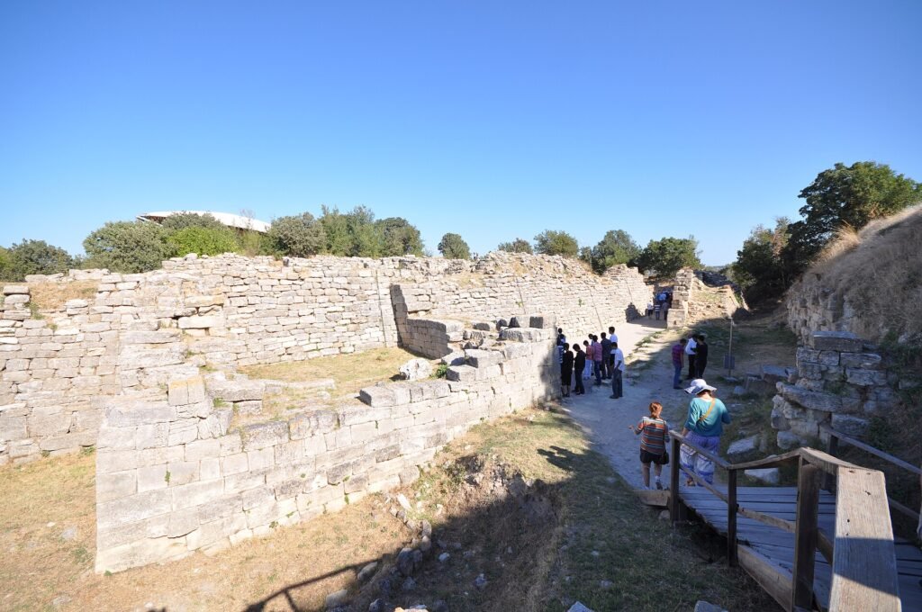
The discovery of Troy was the identification of the ancient city of Homer’s Iliad with the mound of Hisarlık in northwestern Turkey. Frank Calvert dug there in 1863, and Heinrich Schliemann began large excavations in 1870 that exposed a city with about 4,000 years of history.
The site holds nine successive settlements, labeled Troy I to Troy IX, and it is now a UNESCO World Heritage Site. The city is real, but whether the war in the epic happened as told remains an open question.
Background to the discovery of Troy
For centuries Troy was known mainly through literature. The Iliad describes a ten-year siege of the city by a Greek coalition led by Agamemnon of Mycenae, and later Greeks and Romans built a city called Ilion at the place they took to be Troy.
Until archaeologists dug in the right place, the location rested on tradition rather than evidence. The mound of Hisarlık overlooks a plain near the Turkish Aegean coast, about 4.8 kilometers from the southern entrance to the Dardanelles, and it became the leading candidate.
The discovery of Troy
Frank Calvert carried out the first excavation at Hisarlık in 1863. Heinrich Schliemann visited, then took over the work from 1870 and continued until his death in 1890.
Schliemann attacked a conspicuous artificial mound about 20 meters high that had stood untouched since antiquity. His early finds of gold and silver jewelry and vessels convinced him that he had found the city of Homer.
Those treasures have since been dated to more than a thousand years before the probable date of the Trojan War, so they cannot belong to the city of the epic. UNESCO nevertheless describes his excavations as the starting point of modern archaeology and of its public recognition.
His successor, Dörpfeld, continued the work, and the numbered sequence of cities that scholars still use grew out of their original classification. That sequence was later adjusted when radiocarbon dating became available in the early twenty-first century.
How the discovery was confirmed
Confirmation came slowly, through many campaigns rather than one find. UNESCO counts 24 excavation campaigns over roughly 140 years, and together they exposed 23 sections of defensive wall, eleven gates, a paved stone ramp and the lower parts of five bastions.
The digs also revealed 46 levels of occupation grouped into nine cities. Troy I, from about 3000 to 2550 BCE, was a small village surrounded by stone walls, while Troy VI, from about 1750 to 1300 BCE, is the phase most visible today.
Troy VI had limestone fortification walls about 5 meters thick and up to 8 meters high, with towers. Those walls show a prosperous city that cared about defense.
Later phases tell a different story. Troy VIIa, from about 1300 to 1180 BCE, and Troy VIIb, from about 1180 to 950 BCE, had larger lower towns but poorer architecture and craftsmanship, including a return to handmade pottery after centuries of wheel-made ware.
Another line of evidence comes from outside the site. Hittite texts name a land called Wilusa, which scholars connect with the region of which Troy was the capital, and they name Ahhiyawa, usually understood as the Mycenaean Greeks. These documents describe unrest and Mycenaean support for local rebellion near Troy.
Researchers also learned that Troy was larger than the mound suggests. In recent decades work showed that a lower city south of the citadel existed in every prehistoric period and reached about 30 hectares in the Late Bronze Age.
Impact and legacy of the discovery
The discovery changed how people read both archaeology and literature. It showed that a place named in an epic could be found on the ground, and it gave archaeologists a long, layered sequence that is fundamental to understanding this period of the ancient Mediterranean.
UNESCO describes Troy as the most significant evidence of the first contact between the civilizations of Anatolia and the Mediterranean world. The site also records a continuous settlement of more than 3,000 years, so it serves as a reference point for the Bronze Age across the Aegean, the Balkans and Anatolia.
Two phases stand out in UNESCO’s assessment. Troy II and Troy VI are characteristic examples of an ancient eastern city in an Aegean setting, each with a fortified citadel enclosing palaces and administrative buildings and a fortified lower town around it.
The remains are not only prehistoric. After the Bronze Age the Greek and Roman city of Ilion rose on the same ground, and its temple of Athena, odeion (a small concert hall) and bouleuterion (a council house) are still visible.
The surrounding landscape adds context. UNESCO lists prehistoric settlements and cemeteries, Hellenistic burial mounds, Greek and Roman settlements, Roman and Ottoman bridges and monuments of the Battle of Gallipoli, and research there shows that the region has been inhabited for about 8,000 years.
For general readers the site is also a reminder of how a single excavation can shape a field. Schliemann’s methods are now criticized, yet the public attention his work attracted helped make archaeology a recognized discipline.
Disputes over credit and interpretation
Credit for the discovery is shared, and sources describe it differently. The World History Encyclopedia says Calvert first excavated the mound in 1863 and that Schliemann continued from 1870, while UNESCO dates the first excavations to Schliemann in 1870.
Interpretation of the finds is also contested. Most specialists accept that Hisarlık is the setting of the Iliad, but the Luwian Studies foundation lists the historicity of the Trojan War among the questions that are still unsettled.
The evidence does not prove that the specific events of the epic took place. It shows a fortified city that suffered destruction and decline in the period the Greeks later remembered as the age of heroes, and further excavation continues to refine that picture.
More in Archaeology
Key facts
- Troy lies on the mound of Hisarlık in northwestern Turkey, about 4.8 kilometers from the southern entrance to the Dardanelles.1
- Frank Calvert excavated the site in 1863, and Heinrich Schliemann ran larger excavations from 1870 until his death in 1890.2
- Excavations show nine successive cities, Troy I to Troy IX, with 46 levels of occupation.2
- Troy VI, dated about 1750 to 1300 BCE, is the phase most visible at the site today.2
- Twenty-four excavation campaigns over about 140 years have exposed 23 sections of defensive wall and eleven gates.1
Related concepts
Quick checkWho discovered Troy?Show answer
Credit is shared. Frank Calvert dug at Hisarlık in 1863, and Heinrich Schliemann began major excavations in 1870 and made the site famous, while later teams established its nine-city sequence.
Sources
- UNESCO World Heritage Centre, Archaeological Site of Troy, https://whc.unesco.org/en/list/849/
- World History Encyclopedia, Troy, https://www.worldhistory.org/Troy/
- Luwian Studies, Hisarlık (Troy), https://luwianstudies.org/sites/hisarlik-troy
Editorially reviewed by Specialty Digest Editorial TeamLast reviewed November 5, 2026Researched and drafted with AI assistanceReport an issue