NASA’s Earth Observatory reports a Bismarck Sea submarine eruption, a volcanic event in the central sea, north of Papua New Guinea, that began in May 2026. Satellites tracked plumes, thermal anomalies and floating pumice over about a week. This article summarizes the timeline NASA published, explains the main terms and flags what the report does not say.
Where did the eruption happen?
NASA places the eruption probably along the Titan Ridge, about 16 kilometers (10 miles) southeast of the site of a 1972 eruption. The word probably matters, because an eruption under water is located from satellite and seismic clues and not from direct observation.
What was the timeline?
NASA lists these observations:
- May 8: an earthquake swarm
- May 9: plumes seen by the Aqua and Terra satellites
- May 10: Sentinel-2 imagery
- May 11: Landsat 9 imagery
- May 12: thermal anomalies over about 7 square kilometers seen by VIIRS
- May 15: floating pumice and green water seen by MODIS
By our own arithmetic, the record covers eight days from the first swarm to the pumice image. The PACE satellite also detected disturbed water. NASA says ash plumes rose several kilometers.
How big was it?
NASA describes the eruption as less explosive than the Hunga Tonga eruption of 2022 or the Fukutoku-Okanoba eruption of 2021. The report does not give a numeric size in the part we read. Scientists are watching for a new island, which can form when erupted material builds up above the sea surface. We do not know whether one will form.
What is pumice?
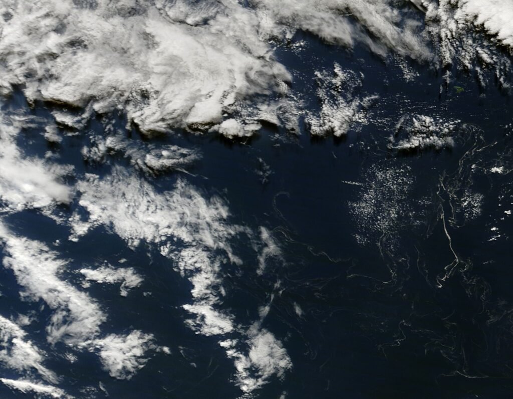
Pumice is a light volcanic rock full of gas bubbles, so it can float. Large amounts can drift as rafts on the sea surface and be seen from space. That is a general explanation and is not quoted from NASA. The picture shown on this page is a pumice raft from a different eruption, near the Kermadec Islands in 2012, and is shown only as an example of what such a raft looks like.
Why do satellites matter for undersea eruptions?
An eruption below the surface is hard to see from land. Different satellites supply different clues: thermal sensors show heat, optical sensors show plumes and water color, and ocean-color instruments show disturbed water. That general point explains why NASA lists so many instruments. For other examples of satellite monitoring, see our reports on Vega Island and coral bleaching.
Why are earthquake swarms a warning sign?
A swarm of small earthquakes can signal magma moving through rock, which is why the May 8 swarm is listed first in the timeline. This is a general geological point and not a claim from the NASA report, and swarms do not always lead to an eruption. Here, the satellite plumes seen on May 9 followed the swarm by one day, by our own arithmetic.
What does the comparison with earlier eruptions tell us?
NASA compares the event with the 1972 eruption nearby and with two better-known eruptions, Hunga Tonga in 2022 and Fukutoku-Okanoba in 2021. The 1972 comparison is about location, since the new site lies about 16 kilometers away. The other two comparisons are about explosiveness, and NASA calls the Bismarck Sea event less explosive. The report does not say how the sizes compare in volume, so readers should not turn the word less into a number.
Why does the sea turn green?
NASA reports green water in the May 15 image. Discolored water around volcanoes can come from dissolved minerals, suspended particles or changes in the tiny organisms that live near the surface. That is a general explanation, and the part of the report we read does not say which cause applies here. The PACE satellite measures ocean color, which is why it could detect disturbed water.
How to read the report
The sequence shows what was seen on which day, and it does not show how much magma was erupted. Thermal anomalies over 7 square kilometers describe a heat footprint on the surface, not the size of the eruption. Readers should avoid comparing it numerically with other eruptions unless a source supplies a common measure.
Could the eruption affect air or sea?
The report mentions ash plumes rising several kilometers and green discolored water. It does not discuss effects on people, air quality or marine life. Readers who want background on airborne particles can see our article on air pollution. We do not draw conclusions about local effects from this report.
What should readers watch for next?
The questions are whether the eruption continues, whether a new island forms and whether later images show lasting changes in the seafloor ridge. NASA’s report does not forecast any of these.
Glossary
- Submarine eruption: a volcanic eruption beneath the sea surface
- Pumice raft: a floating mass of pumice on the sea
- Thermal anomaly: an area hotter than its surroundings in satellite data
- Earthquake swarm: a cluster of many small earthquakes in a short time
- Ridge: a long raised feature on the seafloor
These definitions are general explanations and are not quoted from NASA.
What is not covered here?
We read the NASA report only and did not read seismic or volcanological bulletins. We give no size, depth or casualty information, and none is stated in the part we read.
Key facts at a glance
- Place: central Bismarck Sea, probably the Titan Ridge
- First sign: May 8 earthquake swarm
- Pumice seen: May 15
- Distance from the 1972 site: about 16 kilometers
Frequently asked questions
Was it bigger than Hunga Tonga?
No. NASA calls it less explosive than the 2022 Hunga Tonga eruption.
Did a new island form?
Not reported. Scientists are watching for one.
Which satellites saw it?
Aqua, Terra, Sentinel-2, Landsat 9, VIIRS, MODIS and PACE.
More in Nature